Panoramic satellite images. Map of Russia from satellite online
Can you find satellite photographs that will help you trace the stages of the destruction of Donetsk airport as a result of artillery shelling?
To answer this question, this article will look at three online applications for finding historical satellite photos: , Terraserver and Digital Globe.
For different territories, satellites photograph the Earth's surface at different frequencies, depending on the population of the territory and the interest of users. Therefore, large cities will have more photographs than villages.
Before you start searching for historical photographs, you need to determine geographical coordinates searched places - longitude (longitude) and latitude (latitude). One of the most simple ways– use Google Maps.
For example, to get the coordinates of Donetsk airport, you first need find it on the map using the Google Maps search engine (in the upper left corner). Next, right-click on the map location that interests us (on the airport building) and select “What’s here?” in the list that appears.
Google Maps, “What’s here?”
In the left top corner screen under the “Search” line will appear short description and geographical coordinates of Donetsk airport - 48.067663, 37.741608.

You can also use the convenient online service Mygeoposition.com (uses Google maps) with a clear interface.
On the start day, you need to install the Google Earth program, that is, download it from the link - https://www.google.com/earth/— and go through the installation procedure lasting 5-10 minutes.

In the upper left corner in the “Search” line you need to enter either the coordinates (48.067663, 37.741608) or the name of the object (“Donetsk Airport”). Afterwards the program will show the latest satellite image of the area. You can get closer or further away from an object using the navigation bar like in Google Maps in the right corner of the program.

Google Earth. Navigation
To be able to view historical photographs, you need to select “View” - “Images in time” in the program menu.

A blue bar will appear in the upper left corner on a black background, indicating the valid time range for searching for photos. Light blue vertical bars indicate the dates of available photos. Using the slider or back/forward buttons, you can move through the timeline of historical satellite photos.

In our case, the last available image of Donetsk airport from space was taken on September 3, 2014. By clicking on the “Back” button, you can watch the process of destruction of the airport building. For example, in the photograph dated July 21, 2014, such damage is no longer visible.


TerraServer
If you can't find satellite images of a certain period in Google Earth, you can try searching on the American commercial site Terraserver. You will have to pay for high-quality photographs (from $25 to $225, depending on the image size). But free images can also help.
On home page you need to enter either the longitude/latitude of the object (Coordinates), or indicate the country/city/street (Address) of the desired area.

TerraServer will show the most recent image available. To view historical photographs from a satellite, you need to click the More Images button, after which a list will appear indicating the date and time of available satellite images.

- Also American company, which photographs millions of square kilometers of the Earth's surface every day, supplying images to NASA, Google, TerraServer.

To go to the section with satellite photos, you need to click on Menu – ImageFinder.
On the ImageFinder page, as in similar services, you can search either by object name or by coordinates. To specify coordinates, select the Enter Coordinates button in the Polygon menu.
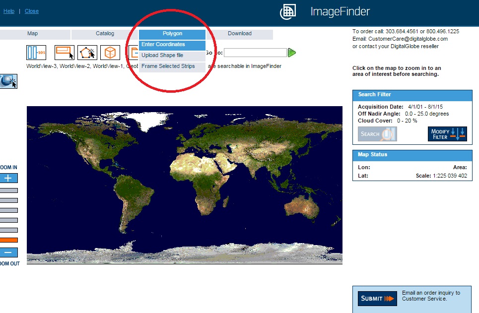
DigitalGlobe. Search by coordinates
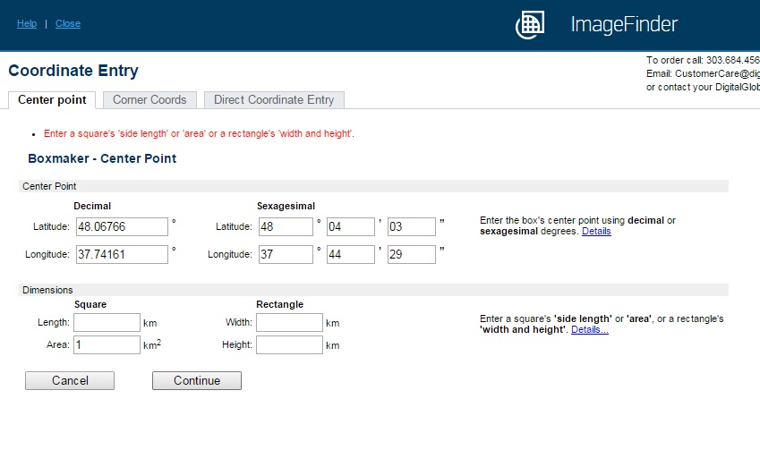
On new page in the Center point tab you need to specify the coordinates of Donetsk airport, and in the Area field enter, for example, 1 (square kilometer), and click Continue. In the Corner Coodrs tab, you can set the terrain search parameters by specifying the coordinates of the upper left and lower right corners.
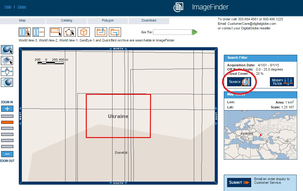
The next step is to click on the Search button on the right side of the screen.
Many users would like to enjoy the satellite map of Russia online, see any memorable places with which many bright and colorful memories are associated. Various can help with this network services, presenting such a possibility in real time. In this material, I will tell you where online you can look at maps of Russia from a satellite, and which network services are the best in 2018.
You can find it online a large number of services that provide the opportunity to view the territory of Russia using photos taken from a satellite. The variety of such services should not be misleading - most of them use the API from Google Maps, some use the capabilities of Yandex.Maps, and a few use maps from the Bing service from Microsoft.
Working with such services is quite simple.

At the same time, a number of services (the same Google Maps and Yandex.Maps) allow you to use the “street view” mode, in which you can virtually walk along selected streets, enjoying the view around you.
Let's consider services that allow us to see a map of Russia from a satellite online.
Google Maps - viewing Russian cities from satellite
The most popular mapping service in the world is Google Maps. It includes a mode for displaying the Earth's territory from a satellite, a street map (including a 360-degree panoramic view). Also, the state of street traffic in real time, planning optimal routes (for pedestrians, cyclists, car drivers), and other convenient features. To view the most popular and beautiful places on our planet, Google has created a service in which a panoramic view is available.
In order to open a map of Russia from a satellite in Google Maps at the bottom left, switch to satellite map display mode. Then, in the search bar, enter the name of the toponym you need in Russia, and press enter (or find it with the mouse).
To enable street view mode, there is a button with a hand-drawn yellow man at the bottom right.

Google Maps is the most visited map service in the world
Yandex.Maps - the best satellite map of Russia
Yandex.Maps is one of the most popular mapping services in Russia. Its popularity among the Russian audience is not surprising - the service boasts the highest frequency of data updates for Russia compared to its competitors (which is especially important for displaying traffic jams). At the same time, its functionality, in addition to satellite maps and the “Street Panoramas and Photography” mode (similar to Google’s Street View mode), includes a tool called “People’s Map”, which is a crowdsourcing data collection system in which each user can edit the map (with condition of moderation).
- To view Russia from a satellite, go to the yandex.ru service.
- In the search bar on the left, you can enter the data of the geographic location you need, or find the establishment you need nearby by clicking on the corresponding button.
- To switch to Street View mode, click on the “Street Panorama and Photos” button at the bottom right.

The initial screen of the service from Yandex makes it possible to quickly find the desired establishment nearby
Infokart.ru – detailed map with views of streets and houses
The domestic service infokart.ru is good primarily because it combines on one page of the site both the functionality of the Bing satellite maps from Microsoft and maps of the non-profit web map project OpenStreetMap.org, allowing you to view maps of Russia from a satellite online.
By going to the infokart.ru service page, you can enjoy both satellite maps of Russia and a detailed map of many Russian cities.

Wikimapia with details down to cities and houses
The international project "Wikimapia" is an online geographical encyclopedia that combines the API from Google.Maps with the principle of free data editing adopted by Wikipedia. The founders of the project were domestic developers Alexander Koryakin and Evgeny Savelyev in 2006. Now the project unites more than 2.5 million users who have entered information about tens of millions of objects into the system database.
The goal of the project is to collect and organize data about geographic objects, information about which can be obtained by anyone.
- To use the site, go to wikimapia.org.
- Select the Russian interface at the top (instead of EN - RU), then in the search bar on the right, enter the name of the object you need to view it.
- To enter your own data (the “Add object” button), or edit existing ones (the “Edit” button), you will need to register in the system.
- The “Categories” button will allow you to search by the desired category (shops, stadiums, hotels, parks, etc.).

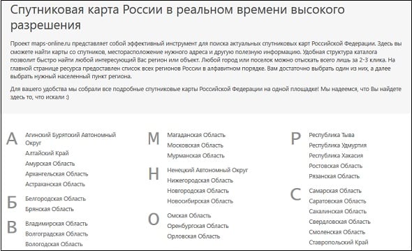
Maps-online.ru – cataloged map service
A special feature of the maps-online.ru card service is properly cataloged information. When you go to the resource, you can select the region of Russia you need, then the region, and the locality.
During the viewing process, you can also choose which satellite maps you need - from Google or from Yandex.
Conclusion
Using the services I have listed, you can easily view maps of Russia from a satellite online. All you have to do is launch the service you like, type the name of the desired locality in the search bar, and then view the resulting image, zooming in or out using the mouse wheel. To display Russia, I can recommend maps from Yandex - they have high level detail and good frequency of updated data.
In contact with
Russia or Russian Federation is unique country, combining European and Asian features. The map of Russia is amazing: the country occupies a huge territory of 17 million km2 and is located simultaneously in Northern Asia and Eastern Europe.
143 million people live in Russia. Russian Federation is a kind of “melting pot of nations”: representatives of more than 200 nationalities live here. The country is a federal republic with a presidential form of government. The country's territory is divided into 46 regions, 9 territories, 21 republics, 4 autonomous okrugs, one autonomous region and 2 federal cities. It is noteworthy that Kaliningrad region is located on the territory of the European Union and has no borders with the Russian Federation.
Today Russia is one of the dynamically developing states that are leading world politics. The Russian Federation is part of numerous world political organizations such as the UN and " Big Eight" Despite the relative stability and significant development of the country since the fall of the Soviet regime, the Russian economy is largely dependent on energy resources, in particular on oil and gas prices.
The capital of Russia is Moscow - one of the most expensive and beautiful cities in the world.
Historical reference
The Russian Federation is the successor to several states. The country traces its history back to 862, when it was formed Kievan Rus. In the 12th century, numerous Russian principalities were located on the territory of Russia, which united in the 15th century. Russian state. In 1721, Tsar Peter I created Russian Empire. In 1917, the revolutionary movement of socialism overthrew the monarchical regime and formed first the Russian Republic, then the RSFSR, and in 1922 the USSR.
During the Soviet regime, the country was separated from other countries of the world by the “Iron Curtain”, some of the consequences of which have not yet been eliminated. In 1991, the USSR collapsed and the Russian Federation emerged.

Must Visit
Russia is a country on whose territory there are many cultural, historical and natural monuments. It is recommended to visit the business and cultural centers of the country - Moscow and St. Petersburg, Lake Baikal, the cities of the Golden and Silver Rings, Orthodox monasteries and temples, Caucasian Reserve, Kamchatka volcanoes and much more.

Interactive map of Russia- modern and convenient way find the desired card any region or city. This map allows you to view cities both in satellite mode and in schematic map mode. You can view from a satellite with the ability to zoom in on any city and switch between different providers and map types. Additional services are available - photos of cloud cover in real time, traffic jams (only for large cities), photos of the area, a weather layer displaying the current weather for each settlement, and a brief forecast for the next 4 days.
For most objects on the map of Russia - Google Maps satellite photos are considered the best in quality
The quality of satellite photography often varies by region, as satellite images need to be constantly updated. Therefore, different providers may have different photo quality for a specific city or region. However, the best quality photos in most cases are found on Google Maps. Photos of Yandex maps are often of lower quality, but they may be newer, so for new buildings you can get by with Yandex. OVI maps - surprisingly, in some cases it has photographs that are even better than those in Google Maps,
Open Street Maps
OSM is a phenomenon of modern computer society, because the map is made simple people(volunteers volunteers), (unlike the 2gis card and others). But despite this, OSM is considered the most accurate and detailed map not only for Russia, but for the whole world. Even such giants as Yandex or Google cannot compile maps as accurately and efficiently as a community of passionate amateur cartographers does. New buildings (and it is by them that it is easy to determine the relevance and “freshness” of the map) are almost always present on OSM (and even the foundations of new buildings), while in Google and Yandex they may be present alternately, or not present at all. In addition, Open Street Maps is probably the only map that displays paths in parks and forests and many other additional objects that are usually not available on other services.

Russia - physical map one file, which shows the most big cities, main ridges and plains. The map is very clear and easy to understand, although not detailed enough.

Physical card - option 2
What are Google Maps? This is a service that consists of several applications provided for free, and includes the mapping site Google Maps and a route planning program (Google Transit). Google Maps offers satellite views for many cities around the world and includes detailed diagram location of streets, houses, travel routes public transport or a car, a guide to various objects, etc.
Features of work
Google Maps is displayed in two variations:
- an ordinary traditional map (analogous to Mercator maps)
- and satellite images (not online, but taken a certain time ago).
The scale of the maps is also based on the Mercator projection, that is, it is constant and changes from the poles to the equator downward.
Another separate project of the corporation is closely related to Google Maps - Google Planet, which corresponds to a globe on which the regions of the Earth's poles are clearly visible.
What locations are satellite imagery available for? Not for everyone, but only for large cities in Russia, England, America, Canada and others.
Not all governments have approved such placement and use of images (since the placement of some objects that are clearly visible on maps can be used by terrorists to plan and carry out attacks).
That is why many objects on maps are shaded. Such “classified” objects include, for example, The White house or the Capitol.
Different places on satellite images are shown in different resolutions - the less populated the area, the less detailed it is. Also, some places in the pictures may be hidden due to cloud shadows.
Google Maps online
- switch to satellite mode- lower left corner;
- zoom in/out- lower right corner.
As soon as the company introduced the new service, a wave of interest in satellite images swept across the world.
The creation of websites began on which satellite images began to be freely available interesting places, unusual architectural landmarks, stadiums, man-made formations. Since 2008, the US Weather Service began using Google Maps to prepare its forecasts.
It should be noted that not all images are taken from a satellite - most of images were obtained through aerial photography from a height of 300 meters.
Google Maps online maps make fairly extensive use of JavaScript. As the user moves around the map by dragging it, new areas are downloaded from the server and displayed on the page.
If the user is looking for specific objects, the search result is inserted into the sidebar, and the page itself does not require a reload. The location on the map is displayed dynamically via a red marker icon.
- In 2006 year the first version for mobile phones, and in 2007 a second version appeared. A service similar to GPS is used to determine the location of the phone.
- In 2008 year Google Maps could be used for Android, Windows Mobile, Symbian, BlackBerry, Java (from 2+), IOS (Apple), Palm OS (Centro+).
- In 2011 In 2018, the corporation announced that it provides mapping services to more than 150 million customers.
To allow owners of third-party sites to use Maps, Google announced in 2005 a free Maps API (Application Programming Interface) service.
The map can be placed on any website using this technology for interaction software. Today there are more than 350 thousand such sites around the world.
Navigation charts may be needed in the most different situations. Either you are lost in the forest, or you are looking for the necessary street in the city. A service that can help you deal with this is Google Maps. It consists of a couple of applications. Namely: from the Google Maps website and Google Transit (routing program). Thanks to the fact that Google transmits data directly from the satellite, with the help of these maps you can find out a detailed route map, house numbers, street names, as well as how you can walk or drive (by car, bus, bicycle) to your destination.
This service is a large reference book covering many areas of life: from traveling to planning a walk or going on vacation.
Appearance
The map can be displayed for users in two versions:- traditionally ( topographic map, analogue of Mercator);
- satellite images (not in online mode, but made some time ago).
A sister project to Google Maps, Google Planet (corresponds to a globe), complements the service of images of the Earth's poles.
Peculiarities
Not all countries disclose information about the location of their facilities. Therefore, places on the map where there are classified areas shaded. These include, for example, the White House, the Capitol.Maps have different resolutions different areas land. The lower the population density of an area, the less details are known about it. Some places on the map are hidden under clouds. Although not all objects were taken from the satellite. The images of some of them were obtained thanks to aerial photography from a height of 300 meters or more. In such places, the detail of the terrain reaches high values.
Service interface
Google Maps is very easy to use. This app was made for people and that's how it works. On the left side there is a button for switching the appearance of cards ( topographical or satellite view). And on the right side of the screen the user can find zoom buttons ( increase and decrease).The system allows its users to enter the address or name of an object and obtain information about its location, address, coordinates, appearance. For some areas, a “what’s there” recognition service is available, and Google Maps will show which object (gas station, museum, store, theater) is located there.
Google online maps javascript service is widely used. New areas of the map appear on the page as the user moves it around the screen. If the address of a specific object has been entered, the page is reloaded and the location of the desired place is displayed on the map with a dynamic red marker icon.
So that the map can be hosted by owners of other sites, Google has announced a free service: API Maps(Application Programming Interface) in 2005. This map can be added to any area of the site. them on this moment there are more than 350 thousand worldwide.
About Google Maps
As of 2011, Google announced that it provides its mapping service to more than 150 million customers. This makes the service one of the largest and most ambitious Internet navigation services.Interactive Google Maps is a free service, courtesy of Google Corporation, which does not contain advertising, but only provides high-quality and verified information about the location and purpose of objects around the world.