What are natural disasters? Natural disasters and cataclysms always cause huge damage to a person.
Over the billions of years of existence of our planet, certain mechanisms have been formed on it by which nature works. Many of these mechanisms are subtle and harmless, while others are large-scale and bring great destruction with them. In this rating, we will talk about the 11 most destructive natural disasters on our planet, some of which can destroy thousands of people and an entire city in a few minutes.
11
A mudflow is a mud or mud-stone stream that suddenly forms in the channels mountain rivers as a result of heavy rains, rapid melting of glaciers or seasonal snow cover. The decisive factor in the occurrence can be deforestation in mountainous areas - the roots of trees hold upper part soil, which prevents the occurrence of mudflow. This phenomenon is short-term and usually lasts from 1 to 3 hours, typical for small streams up to 25-30 kilometers long. On their way, the streams cut deep channels, which are usually dry or contain small streams. The consequences of mudflows are catastrophic.
Imagine that a mass of earth, silt, stones, snow, sand, driven by a strong stream of water, fell on the city from the side of the mountains. This stream will be demolished at the foot of the city buildings along with people, and orchards. All this stream will break into the city, turn its streets into raging rivers with steep banks of destroyed houses. Houses break off their foundations and along with people they are carried away by a stormy stream.
10

Landslide - sliding of the masses rocks down a slope under the influence of gravity, often while maintaining its connectedness and solidity. Landslides occur on the slopes of valleys or river banks, in the mountains, on the shores of the seas, the most grandiose at the bottom of the seas. The displacement of large masses of earth or rock along a slope is caused in most cases by wetting the soil with rainwater so that the mass of soil becomes heavy and more mobile. Such large landslides harm agricultural land, enterprises, and settlements. To combat landslides, bank protection structures and planting of vegetation are used.
Only fast landslides, the speed of which is several tens of kilometers, can cause real natural disasters with hundreds of casualties, when there is no time for evacuation. Imagine that huge pieces of soil are quickly moving from the mountain directly to a village or city, and buildings are destroyed under tons of this earth and people who have not had time to leave the place of the landslide are dying.
9

Sandstorm is atmospheric phenomenon in the form of the transfer of large amounts of dust, soil particles and grains of sand by wind several meters from the ground with a noticeable deterioration in horizontal visibility. At the same time, dust and sand rise into the air and at the same time dust settles on large area. Depending on the color of the soil in a given region, distant objects take on a grayish, yellowish, or reddish hue. It usually occurs when the soil surface is dry and the wind speed is 10 m/s or more.
Most often, these catastrophic phenomena occur in the desert. A sure sign that a sandstorm is about to begin is a sudden silence. Rustles and sounds disappear with the wind. The desert literally freezes. Appears on the horizon small cloud, which grows rapidly and turns into a black-purple cloud. The lost wind rises and very quickly reaches speeds of up to 150-200 km / h. A sandstorm can cover streets within a radius of several kilometers with sand and dust, but the main danger sandstorms wind and poor visibility, which cause car accidents, in which dozens of people are injured, and some even die.
8

An avalanche is a mass of snow that falls or slides off a mountain slope. Snow avalanches pose a considerable danger, causing casualties among climbers, lovers of mountain skiing and snowboarding and causing significant damage to property. Sometimes snow avalanches have catastrophic consequences, destroying entire villages and causing the death of dozens of people. Snow avalanches, to one degree or another, are common in all mountainous regions. In winter, they are the main natural danger of the mountains.
Tones of snow are held on the tops of the mountains due to the force of friction. Large avalanches descend at the moment when the pressure force of the snow mass begins to exceed the force of friction. An avalanche is usually triggered by climatic causes: a sudden change in weather, rain, heavy snowfalls, as well as mechanical effects on the snow mass, including the impact of rockfalls, earthquakes, etc. Sometimes an avalanche can start due to a slight push like a gunshot or pressure on the snow of a man. The volume of snow in an avalanche can reach several million cubic meters. However, even avalanches with a volume of about 5 m³ can be life-threatening.
7

A volcanic eruption is the process of ejection by a volcano onto the earth's surface of incandescent fragments, ash, an outpouring of magma, which, having poured onto the surface, becomes lava. The strongest volcanic eruption can have a time period from several hours to many years. Incandescent clouds of ash and gases capable of moving at speeds of hundreds of kilometers per hour and rising hundreds of meters into the air. The volcano ejects gases, liquids and solids with high temperature. This often causes the destruction of buildings and the death of people. Lava and other red-hot eruptive substances flow down the slopes of the mountain and burn everything they meet on their way, bringing innumerable victims and amazing material losses. The only protection against volcanoes is a general evacuation, so the population must be familiar with the evacuation plan and unquestioningly obey the authorities if necessary.
It is worth noting that the danger from a volcanic eruption exists not only for the region around the mountain. Potentially, volcanoes threaten the life of all life on Earth, so you should not treat these hot guys with condescension. Almost all manifestations of volcanic activity are dangerous. It goes without saying that the danger of boiling lava is understandable. But no less terrible is the ash that literally penetrates everywhere in the form of a continuous gray-black snowfall that fills up streets, ponds, entire cities. Geophysicists claim to be capable of eruptions hundreds of times more powerful than have ever been observed. The largest volcanic eruptions, however, have already occurred on Earth - long before the advent of civilization.
6

A tornado or tornado is an atmospheric vortex that arises in a thundercloud and spreads down, often to the very surface of the earth, in the form of a cloud sleeve or trunk with a diameter of tens and hundreds of meters. Typically, the diameter of a tornado funnel on the ground is 300-400 meters, but if a tornado originated on the surface of the water, this value can be only 20-30 meters, and when the funnel passes over land, it can reach 1-3 kilometers. The largest number tornadoes are recorded on the North American continent, especially in the central states of the United States. Every year, about a thousand tornadoes occur in the United States. The strongest tornado can last up to an hour or more. But most of them exist for no more than ten minutes.
On average, about 60 people die each year from tornadoes, mostly from flying or falling debris. However, it happens that huge tornadoes rush at a speed of about 100 kilometers per hour, destroying all buildings in their path. The maximum recorded wind speed in the largest tornado is about 500 kilometers per hour. During such tornadoes, the death toll can go into the hundreds, and the victims into the thousands, not to mention the material damage. The reasons for the formation of tornadoes have not been fully studied so far.
5

A hurricane or tropical cyclone is a type of weather system low pressure, which occurs over a warm sea surface and is accompanied by powerful thunderstorms, heavy rainfall and storm-force winds. The term “tropical” refers to both the geographical area and the formation of these cyclones in tropical regions. air masses. It is generally accepted, according to the Beaufort scale, that a storm turns into a hurricane at a wind speed of more than 117 km / h. The strongest hurricanes can cause not only extreme downpours, but also big waves on the surface of the sea, storm surges and tornadoes. Tropical cyclones can form and maintain their strength only over the surface of large bodies of water, while over land they quickly lose strength.
A hurricane can cause downpours, tornadoes, small tsunamis and floods. A direct effect of tropical cyclones on land is storm winds that can destroy buildings, bridges, and other man-made structures. The strongest permanent winds within the cyclone exceed 70 meters per second. The worst effect of tropical cyclones in terms of casualties has historically been storm surge, that is, the rise in sea level due to the action of the cyclone, which on average results in about 90% of casualties. Over the last two centuries tropical cyclones resulted in the deaths of 1.9 million people worldwide. In addition to the direct effect on residential buildings and economic facilities, tropical cyclones destroy infrastructure, including roads, bridges, power lines, causing enormous economic damage to the affected areas.
most destructive and terrible hurricane in US history - Katrina, occurred at the end of August 2005. The most severe damage was caused to New Orleans in Louisiana, where about 80% of the city's area was under water. As a result of the natural disaster, 1,836 residents were killed and the economic damage amounted to $125 billion.
4

Flooding - flooding of the area as a result of rising water levels in rivers, lakes, seas due to rain, rapid snowmelt, wind surge of water on the coast and other causes, which damages people's health and even leads to their death, and also causes material damage . For example, in mid-January 2009 there was the largest flood in Brazil. More than 60 cities were affected then. About 13 thousand people left their homes, more than 800 people died. Floods and numerous landslides are caused by heavy rains.
Heavy monsoon rains have continued in Southeast Asia since mid-July 2001, causing landslides and flooding in the Mekong River region. As a result, Thailand experienced the worst floods in over half a century. Streams of water flooded villages, ancient temples, farms and factories. At least 280 people have died in Thailand, and another 200 in neighboring Cambodia. About 8.2 million people in 60 of Thailand's 77 provinces were affected by the floods, and economic losses are currently estimated to exceed $2 billion.

Drought - long period stable weather from high temperatures air and low rainfall, as a result of which the moisture reserves of the soil decrease and oppression and death of cultural crops occur. The onset of a severe drought is usually associated with the establishment of an inactive high anticyclone. The abundance of solar heat and gradually decreasing air humidity create increased evaporation, and therefore soil moisture reserves are depleted without replenishment by rains. Gradually, as soil drought intensifies, ponds, rivers, lakes, springs dry up, and a hydrological drought begins.
For example, in Thailand, almost every year, severe floods alternate with severe droughts, when a state of emergency is declared in dozens of provinces, and several million people somehow feel the effects of the drought. As for the victims of this natural phenomenon, only in Africa from 1970 to 2010 the death toll from droughts is 1 million people.
2

Tsunamis are long waves generated by powerful impact the entire water column in the ocean or other body of water. Most tsunamis are caused by underwater earthquakes, during which there is a sharp displacement of the seabed. Tsunamis are formed during an earthquake of any strength, but those that arise due to strong earthquakes with a magnitude greater than 7 on the Richter scale. As a result of an earthquake, several waves propagate. More than 80% of tsunamis occur on the periphery of the Pacific Ocean. First scientific description The phenomenon was given by José de Acosta in 1586 in Lima, Peru after a powerful earthquake, then a strong tsunami 25 meters high burst onto land at a distance of 10 km.
The largest tsunamis in the world occurred in 2004 and 2011. So, on December 26, 2004 at 00:58 there was a powerful earthquake with a magnitude of 9.3 - the second most powerful of all recorded, which caused the deadliest of all known tsunamis. The tsunami affected the countries of Asia and African Somalia. Total amount the dead exceeded 235 thousand people. The second tsunami happened on March 11, 2011 in Japan after a strong earthquake of magnitude 9.0 with an epicenter caused a tsunami with a wave height exceeding 40 meters. In addition, the earthquake and the ensuing tsunami caused the Fukushima I nuclear accident. injured.
1

An earthquake is the tremors and vibrations of the Earth's surface caused by natural causes. Small shocks can also be caused by the rise of lava during volcanic eruptions. About a million earthquakes occur every year all over the Earth, but most of them are so small that they go unnoticed. The most powerful earthquakes, capable of causing widespread destruction, occur on the planet about once every two weeks. Most of them fall on the bottom of the oceans, and therefore are not accompanied by catastrophic consequences if the earthquake does without a tsunami.
Earthquakes are best known for the devastation they can cause. The destruction of buildings and structures is caused by ground vibrations or giant tidal waves (tsunamis) that occur during seismic displacements on the seabed. A powerful earthquake begins with the rupture and movement of rocks in some place deep in the Earth. This place is called the earthquake focus or hypocenter. Its depth is usually no more than 100 km, but sometimes it reaches up to 700 km. Sometimes the focus of an earthquake can be near the surface of the Earth. In such cases, if the earthquake is strong, bridges, roads, houses and other structures are torn and destroyed.
The largest natural disaster is considered to be an earthquake of magnitude 8.2 on July 28, 1976 in the Chinese city of Tangshan, Hebei province. According to official data from the Chinese authorities, the death toll was 242,419 people, however, according to some estimates, the death toll reaches 800,000 people. At 3:42 local time, the city was destroyed by a strong earthquake. Destruction also took place in Tianjin and in Beijing, located just 140 km to the west. As a result of the earthquake, about 5.3 million houses were destroyed or damaged so much that it was impossible to live in them. Several aftershocks, the strongest of which had a magnitude of 7.1, led to even more casualties. The Tangshan earthquake is the second largest earthquake in history after the most devastating Shaanxi earthquake in 1556. Then about 830 thousand people died.
Often in the news you can hear that a natural disaster has happened somewhere. This means that a strong storm or hurricane swept through, an earthquake occurred, or a turbulent mud stream descended from the mountains. Tsunamis, floods, tornadoes, volcanic eruptions, landslides, drought - all these natural phenomena are devastating, they kill people, demolish houses, neighborhoods, and sometimes entire cities from the face of the earth, causing serious economic damage.
Definition of a cataclysm
What does the word "cataclysm" mean? This is, by definition explanatory dictionary Ushakov, a sharp change in the conditions of organic life, which is observed on a significant surface of the Earth (planet) and is due to the influence of atmospheric, volcanic and geological processes.
The explanatory dictionary edited by Efremov and Shvedov defines a cataclysm as a destructive change in nature, a catastrophe.
Also, in each dictionary it is indicated that in figurative meaning cataclysm is a global and destructive change in the life of society, a disastrous social upheaval.
Of course, you can see common features in all definitions. As you can see, the main meaning that the concept of "cataclysm" carries in itself is destruction, disaster.
Types of natural and social disasters

Depending on the source of occurrence, the following types of disasters are distinguished:
- geological - earthquake or volcanic eruption, mudflow, landslide, avalanche or collapse;
- hydrological - tsunami, flood, breakthrough to the surface from the depths of a gas reservoir (CO 2);
- thermal - forest or peat fire;
- meteorological - hurricane, storm, tornado, cyclone, snowstorm, drought, hail, prolonged downpour.
These natural disasters differ in character and duration (from several minutes to several months), but they all pose a threat to human life and health.
IN separate category distinguish man-made disasters - accidents at nuclear installations, chemical facilities, treatment facilities, dam bursts and other disasters. Their occurrence provokes a symbiosis of natural forces and the anthropogenic factor.
The most famous social cataclysm is war, revolution. Also, social emergencies can be associated with overpopulation, migration, epidemics, global unemployment, terrorism, genocide, separatism.
The most terrible cataclysms in the history of the Earth

In 1138, a powerful earthquake occurred in the city of Aleppo (modern Syria), which completely wiped the city off the face of the earth and claimed 230 thousand human lives.
In December 2004, a 9.3 magnitude underwater earthquake hit the Indian Ocean. It triggered a tsunami. Huge 15-meter waves reached the shores of Thailand, India and Indonesia. The number of victims reached 300 thousand people.
In August 1931 in China, due to monsoon rains there was a severe flood that claimed the lives of 4 million (!) People. And in August 1975, due to a powerful typhoon in China, the Banqiao Dam was destroyed. This provoked the largest flood in the last 2000 years, the water went 50 kilometers deep into the mainland, created artificial reservoirs with a total area of 12 thousand km2. As a result, the death toll reached 200 thousand people.
What can expect the blue planet in the future
Scientists predict that strong catastrophes and cataclysms await our planet in the future.
Global warming, which has been worrying progressive minds for more than 50 years, may in the future provoke unprecedented floods, droughts, heavy rains, which will lead not only to millions of victims, but also to a global economic and social crisis.
Also, do not forget that the asteroid 99942 weighing 46 million tons and 500 meters in diameter is inexorably approaching our planet. Astronomers predict a likely collision in 2029 that will destroy the Earth. NASA has created a special working group to solve this very serious
Natural disasters and cataclysms always cause huge damage to a person., as physical ( fatal outcome), and moral (experiences and fear). As a result, terrible harmful natural phenomena (such as tsunamis, tornadoes and tornadoes, floods, hurricanes, storms, etc.) are becoming an increasing threat to people.
Term - natural disasters - is used for two different concepts, in some sense overlapping. Catastrophe in literal translation means - a turn, a restructuring. This value corresponds to the most general idea about catastrophes in natural science, where the evolution of the Earth is seen as a series of different catastrophes that cause a change in geological processes and types of living organisms.
Also the concept - natural disasters refers only to extreme natural phenomena and processes resulting in loss of life. In this understanding - natural disasters opposed - technogenic disasters, i.e. those caused directly by human activity.
Natural disaster is an event caused by natural causes, the destructive effect of which manifests itself within a fairly wide spatio-temporal parameters and causes the death and / or injury of people, as well as significant temporary or permanent changes in the living communities that it affects. It also causes significant material damage due to the adverse impact on human activities and biological resources.
Global natural disasters can be called both very large, but not fatal for mankind catastrophes, and those that lead to the extinction of mankind.
Natural disasters in the generally accepted sense have always been one of the elements of global ecodynamics. Natural disasters and various natural cataclysms in the past occurred in accordance with the development of natural natural trends, and since the 19th century, anthropogenic factors began to influence their dynamics. The deployment of engineering activities in the 20th century and the formation of a complex socio-economic structure of the world dramatically increased not only the proportion of anthropogenic natural disasters, but also changed the characteristics environment with giving them dynamics towards the deterioration of the habitat of living beings, including humans.
Every year, the number of natural disasters in the world increases, on average, by about 20 percent. Such a disappointing conclusion was made by specialists of the International Federation of the Red Cross and Red Crescent Society.
For example, in 2006 there were 427 natural disasters in the world. Most of the deaths were recorded as a result of earthquakes, tsunamis, and floods. Over the past 10 years, the death rate in disasters has increased from 600 thousand to 1.2 million people a year, and the number of victims has increased from 230 to 270 million.
Some catastrophes occur under the earth's surface, others - on it, others - in the water shell (hydrosphere), and the last in the air shell (atmosphere) of the Earth.
Earthquakes and volcanic eruptions, acting from below on the earth's surface, lead to surface catastrophes, such as landslides or tsunamis, as well as fires. Other surface catastrophes occur under the influence of processes in the atmosphere, where temperature and pressure drops are equalized and energy is transferred to the water surface.
As with all natural processes, natural disasters are interconnected. One catastrophe affects another, it happens that the first catastrophe serves as a trigger for subsequent ones.
The closest relationship exists between earthquakes and tsunamis, volcanic eruptions and fires. Tropical cyclones almost always cause flooding. Earthquakes can also cause landslides. Those, in turn, can block river valleys and cause floods. There is a mutual relationship between earthquakes and volcanic eruptions: earthquakes caused by volcanic eruptions are known, and, conversely, volcanic eruptions caused by the rapid movement of masses under the Earth's surface. Tropical cyclones can be a direct cause of both river and sea flooding. Atmospheric disturbances and heavy rainfall can affect slope creep.
Earthquakes are underground shocks and vibrations of the Earth's surface caused by natural causes (mainly tectonic processes). In some places on the Earth, earthquakes occur frequently and sometimes reach great strength, breaking the integrity of the soil, destroying buildings and causing loss of life.
The number of earthquakes recorded annually on the globe is in the hundreds of thousands. However, the vast majority of them are weak, and only a small proportion reaches the degree of catastrophe.
The area of occurrence of an underground impact - the focus of an earthquake - is a certain volume in the thickness of the Earth, within which the process of releasing energy accumulated for a long time takes place. In a geological sense, a focus is a gap or a group of gaps along which an almost instantaneous movement of masses occurs. In the center of the focus, a point is conventionally distinguished, called the hypocenter. The projection of the hypocenter onto the Earth's surface is called the epicenter. Around it is the region of the greatest destruction - the pleistoseist region. Lines connecting points with the same vibration intensity (in points) are called isoseists.
Seismic waves are recorded using instruments called seismographs. Nowadays, they are very complex electronic devices that make it possible to capture the weakest vibrations. earth's surface.
There is a need for a simple and objective determination of the magnitude of earthquakes, and with the help of such a measure that could be easily calculated and freely compared. This kind of scale was proposed by the Japanese scientist Wadachi in 1931. In 1935, it was improved by the famous American seismologist C. Richter. Such an objective measure of the magnitude of earthquakes is the magnitude, denoted by M.
The characteristic of the earthquake strength depending on the value of M can be presented in the form of a table:
Richter scale characterizing the magnitude of earthquakes
|
Characteristic |
|
|
The weakest earthquake that can be recorded using instruments |
|
|
Felt near the epicenter. About 100,000 such earthquakes are recorded annually. |
|
|
Minor damage may be observed near the epicenter |
|
|
Approximately equivalent to the energy of one atomic bomb |
|
|
In a limited area can cause significant damage. Annually such there are about 100 earthquakes |
|
|
From this level, earthquakes are considered strong |
The Great Chilean earthquake (or the Valdivian earthquake) is the strongest earthquake in the history of observation, its magnitude, according to various estimates, was from 9.3 to 9.5. The earthquake occurred on May 22, 1960, its epicenter was located near the city of Valdivia, 435 kilometers south of Santiago.
The tremors caused a powerful tsunami, the wave height of which reached 10 meters. The number of victims was about 6 thousand people, and the main part of the people died precisely from the tsunami. Huge waves caused severe damage around the world, killing 138 people in Japan, 61 people in Hawaii and 32 in the Philippines. The damage in 1960 prices amounted to about half a billion dollars.
On March 11, 2011, an earthquake of magnitude 9.0 on the Richter scale struck east of Honshu Island. This earthquake is considered the most powerful in the entire known history of Japan.
Tremors caused the strongest tsunami (up to 7 meters in height), which killed about 16 thousand people. Moreover, the earthquake and tsunami impact were the cause of the accident at the Fukushima-1 nuclear power plant. The total damage from the disaster is estimated at $14.5-$36.6 billion.
North Sumatra, Indonesia, 2004 - magnitude 9.1-9.3
An undersea earthquake in the Indian Ocean on 26 December 2004 triggered a tsunami that has been recognized as the deadliest natural disaster in modern history. The magnitude of the earthquake was, according to various estimates, from 9.1 to 9.3. This is the third strongest earthquake in the history of observation.
The epicenter of the earthquake was located not far from the Indonesian island of Sumatra. The earthquake triggered one of the most destructive tsunamis in history. The height of the waves exceeded 15 meters, they reached the shores of Indonesia, Sri Lanka, southern India, Thailand and a number of other countries.
The tsunami almost completely destroyed the coastal infrastructure in the east of Sri Lanka and the northwestern coast of Indonesia. Died, according to various estimates, from 225 thousand to 300 thousand people. The damage from the tsunami amounted to about $10 billion.
Tsunami (Japanese) - marine gravity waves of very large length, resulting from the upward or downward displacement of extended sections of the bottom during strong underwater and coastal earthquakes and, occasionally, due to volcanic eruptions and other tectonic processes. Due to the low compressibility of water and the speed of the process of deformation of the bottom sections, the water column resting on them also shifts without having time to spread, as a result of which a certain elevation or depression forms on the ocean surface. The resulting perturbation turns into oscillatory movements of the water column - tsunami waves propagating at high speed (from 50 to 1000 km / h). The distance between neighboring wave crests varies from 5 to 1500 km. The height of the waves in the area of their occurrence varies between 0.01-5 m. Near the coast, it can reach 10 m, and in unfavorable relief areas (wedge-shaped bays, river valleys, etc.) - over 50 m.
About 1000 cases of tsunamis are known, of which more than 100 had catastrophic consequences, which caused complete destruction, washing away of structures and soil and vegetation cover. 80% of tsunamis occur on the periphery of the Pacific Ocean, including the western slope of the Kuril-Kamchatka Trench. Based on the patterns of occurrence and spread of tsunamis, the zoning of the coast is carried out according to the degree of threat. Measures for partial protection against tsunamis: creation of artificial coastal structures (breakwaters, breakwaters and embankments), planting forest strips along the ocean coast
Flooding - significant flooding of the area with water as a result of a rise in the water level in a river, lake or sea, caused by various reasons. Flooding on the river occurs from a sharp increase in the amount of water due to the melting of snow or glaciers located in its basin, as well as as a result of heavy precipitation. Flooding is often caused by an increase in the water level in the river due to blockage of the channel by ice during ice drift (jam) or due to clogging of the channel under the immovable ice cover by accumulations of intra-water ice and the formation of an ice plug (jam). Floods often occur under the influence of winds that bring water from the sea and cause an increase in the level due to the delay at the mouth of the water brought by the river.
Petersburg flood, 1824, about 200-600 dead. On November 19, 1824, a flood occurred in St. Petersburg, which killed hundreds of human lives and destroyed many houses. Then the water level in the Neva River and its canals rose by 4.14 - 4.21 meters above the usual level (ordinary).
Flood in China, 1931, about 145 thousand - 4 million dead. From 1928 to 1930, China suffered from a severe drought. But at the end of the winter of 1930, heavy snowstorms began, and in the spring - incessant heavy rains and thaw, due to which the water level in the Yangtze and Huaihe rivers rose significantly. For example, in the Yangtze River only in July, the water rose by 70 cm. As a result, the river overflowed its banks and soon reached the city of Nanjing, which was then the capital of China. Many people drowned and died from water-borne infectious diseases such as cholera and typhoid. Cases of cannibalism and infanticide among desperate residents are known. According to Chinese sources, about 145 thousand people died as a result of the flood, while Western sources claim that the death toll was from 3.7 million to 4 million.
Landslides - sliding displacement of rock masses down the slope under the influence of gravity. Landslides occur in any part of a slope or slope due to an imbalance in rocks caused by: an increase in the steepness of the slope as a result of water washing; weakening of the strength of rocks during weathering or waterlogging by precipitation and groundwater; the impact of seismic shocks; construction and economic activities carried out without taking into account the geological conditions of the area (destruction of slopes by road cuts, excessive watering of gardens and vegetable gardens located on slopes, etc.). Most often, landslides occur on slopes composed of alternating water-resistant (clay) and water-bearing rocks (for example, sand-gravel, fractured limestone). The development of a landslide is facilitated by such an occurrence when the layers are located with an inclination towards the slope or are crossed by cracks in the same direction. In highly moistened clay rocks, landslides take the form of a stream.
Landslide in Southern California in 2005. Powerful downpours that hit Southern California and the resulting floods, mudflows and landslides have claimed the lives of more than 20 people.
South Korea - August 2011
59 people died. 10 are listed as missing.
Heavy rainfall, which was observed to be the heaviest in recent times.
Volcanoes (named after the fire god Vulcan), geological formations that arise above channels and cracks in earth's crust, along which lava, hot gases and rock fragments are erupted to the earth's surface from deep magmatic sources. Volcanoes usually represent individual mountains composed of eruptions.
Volcanoes are divided into active, dormant and extinct. The former include: those that are currently erupting constantly or periodically; about the eruptions of which there are historical data; about the eruptions of which there is no information, but which emit hot gases and water (solfatar stage). Dormant volcanoes are those whose eruptions are not known, but they have retained their shape and local earthquakes occur under them. Extinct volcanoes are called heavily destroyed and eroded volcanoes without any manifestations of volcanic activity.
Eruptions are long-term (for several years, decades and centuries) and short-term (measured by hours).
An eruption usually begins with an increase in gas emissions, first along with dark, cold lava fragments, and then with red-hot ones. These emissions are in some cases accompanied by an outpouring of lava. The height of the rise of gases, water vapor, saturated with ash and lava fragments, depending on the strength of the explosions, ranges from 1 to 5 km (during the Bezymyanny eruption in Kamchatka in 1956, it reached 45 km). The ejected material is transported over distances from several to tens of thousands of kilometers. The volume of ejected clastic material sometimes reaches several km3.
During some eruptions, the concentration of volcanic ash in the atmosphere is so great that there is darkness, similar to darkness in an enclosed space. This took place in 1956 in the village of Klyuchi, located 40 km from V. Bezymyanny.
The products of volcanic eruptions are gaseous (volcanic gases), liquid (Lava) and solid (volcanic rocks).
Modern volcanoes are located along young mountain ranges or along large faults (grabens) for hundreds and thousands of kilometers in tectonically mobile areas (see table). Almost two-thirds of the volcanoes are concentrated on the islands and shores of the Pacific Ocean (Pacific volcanic belt). The Atlantic Ocean region stands out from other regions in terms of the number of active volcanoes.
Vesuvius, 79 AD
During the eruption, Vesuvius threw a deadly cloud of ash and smoke to a height of 20.5 km, and every second erupted about 1.5 million tons of molten rock and crushed pumice. At the same time, a huge amount of thermal energy was released, which many times exceeded the amount released during the explosion. atomic bomb over Hiroshima.
Tornadoes are catastrophic atmospheric vortices having the shape of a funnel with a diameter of 10 to 1 km. In this vortex, the wind speed can reach an incredible value - 300 m / s (which is more than 1000 km / h).
The forward speed of a tornado is 40 km / h, which means that you can’t run away from it, you can only leave by car. Escape from a tornado, however, is also problematic in this case, since its route is absolutely irregular and unpredictable.
A tornado is somewhat reminiscent of a cyclone, for example, in its circular whirling of air or in the fact that there is low pressure in the center of the funnel.
In the deserts of the United States, there are two types of eddy winds - classic tornadoes and the so-called "desert devils". Tornadoes are associated with thunderclouds, while inverted "desert devil" funnels are not associated with cloud formations.
The origin of a tornado is not completely understood. Obviously, they are formed at moments of unstable air stratification, when the heating of the earth's surface leads to heating of the lower layer of air as well. Above this layer there is a layer of colder air, this situation is unstable. Warm air rushes up, while cold air in a whirlwind, like a trunk, descends down to the earth's surface. Often this occurs over small, elevated areas within flat terrain.
There is a scale, similar to those used to determine the intensity of earthquakes or the strength of the wind, which determines the strength of a tornado.
Strong tornadoes leave a strip of devastated land behind them. Roofs are torn off houses, trees are uprooted from the ground, people and cars are lifted into the air. When the path of a tornado runs through a densely populated area, the number of victims reaches a significant value. So, on April 11, 1965, 37 tornadoes arose over the territory of the Midwest of the United States, which caused the death of 270 people. Tornadoes are most frequently reported in the United States of America.
Statistics on the number of victims of tornadoes are inaccurate. Over the past 50 years, up to 30 people have died from them annually in the United States alone.
Tornado protection is problematic. They appear unexpectedly. It is impossible to determine their trajectory. The transmission of warnings by telephone from city to city can help. The best and, apparently, the only defense against a tornado is to take cover in the basement or in a solid building.
Oklahoma 2013. According to scientists, the speed of EF5-type vortices is more than 322 kilometers per hour (89 meters per second). The width of the tornado was two kilometers, duration - 40 minutes. According to meteorologists, less than one percent of all tornadoes in the United States reach such a force, that is, about ten tornadoes per year. Previously, experts tentatively rated Oklahoma tornado power one point lower, that is, four points out of five on the improved Fujita scale.
About 24 dead. 237 people suffered.
Natural disasters and their impact on change
physical and geographical location
The physical-geographical position is the spatial location of any area in relation to the physical-geographical data (equator, prime meridian, mountain systems, seas and oceans, etc.).
The physical and geographical position is determined by geographical coordinates (latitude, longitude), absolute altitude in relation to sea level, proximity (or remoteness) to the sea, rivers, lakes, mountains, etc., position in the composition (location) of natural (climatic, soil-vegetative, zoogeographic) zones. This is the so-called. elements or factors of physical and geographical location.
The physical and geographical position of any locality is purely individual, unique. The place occupied by each territorial entity, not only individually in itself (in the system geographical coordinates), but also in its spatial environment, i.e., in its location in relation to the elements of the physical and geographical position. Consequently, a change in the physical-geographical position of any locality leads, as a rule, to a change in the physical-geographical position of neighboring localities.
A rapid change in the physical and geographical position can only be due to natural disasters or the activities of man himself.

Hazardous natural phenomena include all those that deviate the state of the natural environment from the range that is optimal for human life and for their economy. Cataclysmic natural disasters include those that change the face of the earth.
These are catastrophic processes of endogenous and exogenous origin: earthquakes, volcanic eruptions, tsunamis, floods, avalanches and mudflows, landslides, subsidence of soils, sudden onset of the sea, global climate change on Earth, etc.
In this paper, we will consider physical and geographical changes that have ever occurred or are occurring in our time under the influence of natural disasters.
CHARACTERISTICS OF NATURAL DISASTERS
earthquakes

Earthquakes are the main source of physical and geographical changes.
An earthquake is a shaking of the earth's crust, underground shocks and vibrations of the earth's surface, caused mainly by tectonic processes. They manifest themselves in the form of tremors, often accompanied by an underground rumble, undulating vibrations of the soil, the formation of cracks, the destruction of buildings, roads and, most sadly, human casualties. Earthquakes play a significant role in the life of the planet. More than 1 million tremors are recorded annually on Earth, which averages about 120 shocks per hour or two shocks per minute. We can say that the earth is in a state of constant trembling. Fortunately, few of them are destructive and catastrophic. There is an average of one catastrophic earthquake and 100 destructive ones per year.

Earthquakes occur as a result of the pulsating-vibrational development of the lithosphere - its compression in some regions and expansion in others. At the same time, tectonic breaks, displacements and uplifts are observed.

At present, zones of earthquakes of different activity have been identified on the globe. The areas of strong earthquakes include the territories of the Pacific and Mediterranean belts. In our country, more than 20% of the territory is prone to earthquakes.
Catastrophic earthquakes (9 points or more) cover the areas of Kamchatka, the Kuril Islands, Pamir, Transbaikalia, Transcaucasia and a number of other mountainous regions.
Strong (from 7 to 9 points) earthquakes occur in a territory stretching in a wide strip from Kamchatka to the Carpathians, including Sakhalin, the Baikal region, the Sayans, Crimea, Moldova, etc.

As a result of catastrophic earthquakes, large disjunctive dislocations appear in the earth's crust. Thus, during the catastrophic earthquake on December 4, 1957 in the Mongolian Altai, the Bogdo fault, about 270 km long, appeared, and the total length of the resulting faults reached 850 km.

Earthquakes are caused by sudden, rapid displacements of the wings of existing or newly formed tectonic faults; the voltages that arise in this case are capable of being transmitted over long distances. The occurrence of earthquakes on large faults occurs during a long-term displacement in opposite directions of tectonic blocks or plates that are in contact along the fault. At the same time, cohesive forces keep the fault wings from slipping, and the fault zone experiences a gradually increasing shear deformation. When it reaches a certain limit, the fault “rips open” and its wings are displaced. Earthquakes on newly formed faults are considered as a result of the regular development of systems of interacting cracks that combine into a zone of increased concentration of faults, in which a main fault is formed, accompanied by an earthquake. The volume of the medium, where part of the tectonic stresses are removed and a certain fraction of the accumulated potential energy of deformation is released, is called the earthquake source. The amount of energy released during one earthquake depends mainly on the size of the shifted fault surface. The maximum known length of faults that rupture during an earthquake is in the range of 500-1000 km (Kamchatka - 1952, Chile - 1960, etc.), the wings of the faults were displaced to the sides up to 10 m. The spatial orientation of the fault and the direction of displacement its wings are called the earthquake focal mechanism.

Earthquakes capable of changing the face of the Earth are catastrophic earthquakes with magnitude X-XII points. Geological consequences of earthquakes, leading to physical and geographical changes: cracks appear on the ground, sometimes gaping;
air, water, mud or sand fountains appear, while accumulations of clay or piles of sand are formed;
some springs and geysers stop or change their action, new ones appear;
groundwater becomes cloudy (stirred);
landslides, mud and mudflows, landslides occur;
there is a liquefaction of the soil and sandy-clayey rocks;
underwater creep occurs, and turbidity (turbidite) flows are formed;
coastal cliffs, river banks, bulk areas collapse;
seismic sea waves (tsunami) occur;
snow avalanches break down;
icebergs break off ice shelves;
zones of rift-type disturbances with internal ridges and dammed lakes are formed;
the soil becomes uneven with areas of subsidence and swelling;
seiches occur on lakes (standing waves and churning of waves off the coast);
the regime of ebbs and flows is violated;
volcanic and hydrothermal activity is activated.
Volcanoes, tsunamis and meteorites

Volcanism is a set of processes and phenomena associated with the movement of magma in the upper mantle, the earth's crust and on the surface of the earth. As a result of volcanic eruptions, volcanic mountains, volcanic lava plateaus and plains, crater and dam lakes, mud flows, volcanic tuffs, cinders, breccias, bombs, ash, volcanic dust and gases are emitted into the atmosphere.
Volcanoes are located in seismically active zones, especially in the Pacific. In Indonesia, Japan, Central America, there are several dozen active volcanoes - in total on land from 450 to 600 active and about 1000 "sleeping" volcanoes. About 7% of the world's population is dangerously close to active volcanoes. There are at least several dozen large underwater volcanoes on the mid-ocean ridges.
In Russia, Kamchatka, the Kuril Islands, and Sakhalin are exposed to the danger of volcanic eruptions and tsunamis. There are extinct volcanoes in the Caucasus and Transcaucasia.

The most active volcanoes erupt on average once every few years, all currently active volcanoes erupt on average once every 10-15 years. In the activity of each volcano there are, apparently, periods of relative decrease and increase in activity, measured in thousands of years.
Tsunamis often occur during eruptions of island and underwater volcanoes. Tsunami is a Japanese term for an unusually large sea wave. These are waves of great height and destructive force that occur in zones of earthquakes and volcanic activity of the ocean floor. The speed of such a wave can vary from 50 to 1000 km/h, the height in the area of origin is from 0.1 to 5 m, and near the coast - from 10 to 50 m or more. Tsunamis often cause destruction on the coast - in some cases catastrophic: they lead to erosion of the coast, the formation of turbidity flows. Another cause of ocean tsunamis are underwater landslides and avalanches breaking into the sea.

.jpg)

About 70 seismogenic tsunamis have been recorded in the last 50 years dangerous dimensions, of which 4% in the Mediterranean, 8% in the Atlantic, the rest in pacific ocean. The most tsunami-prone shores are Japan, the Hawaiian and Aleutian Islands, Kamchatka, the Kuril Islands, Alaska, Canada, the Solomon Islands, the Philippines, Indonesia, Chile, Peru, New Zealand, the Aegean, Adriatic and Ionian Seas. In the Hawaiian Islands, tsunamis with an intensity of 3-4 points occur on average 1 time in 4 years, on the Pacific coast South America- once every 10 years.
Flooding is a significant flooding of an area as a result of a rise in the water level in a river, lake or sea. Floods are caused by heavy rainfall, melting snow, ice, hurricanes and storms, which contribute to the destruction of bulk structures, dams, dams. Floods can be river (floodplain), surge (on the coasts of the seas), planar (flooding of vast watershed areas), etc.

Large catastrophic floods are accompanied by a rapid and high rise in the water level, a sharp increase in the speed of flows, their destructive power. Devastating floods occur almost every year in various regions of the earth. In Russia, they are most frequent in the south of the Far East.

flooding in the Far East in 2013
Disasters of cosmic origin are of no small importance. The Earth is constantly bombarded by cosmic bodies ranging in size from fractions of a millimeter to several meters. How larger size body, the less often it falls on the planet. Bodies with a diameter greater than 10 m, as a rule, invade the Earth's atmosphere, only weakly interacting with the latter. The bulk of matter reaches the planet. The speed of cosmic bodies is enormous: approximately from 10 to 70 km/s. Their collision with the planet leads to strong earthquakes, an explosion of the body. At the same time, the mass of the destroyed substance of the planet is hundreds of times greater than the mass of the fallen body. Huge masses of dust rise into the atmosphere, shielding the planet from solar radiation. The earth is cooling. The so-called "asteroid" or "comet" winter is coming.
According to one hypothesis, one of these bodies that fell in the Caribbean hundreds of millions of years ago led to significant physical and geographical changes in the area, the formation of new islands and reservoirs, and along the way to the extinction of most of the animals that inhabited the Earth, in particular dinosaurs. .

Some space bodies could fall into the sea in historical times (5-10 thousand years ago). According to one version, the global flood, described in the legends of different peoples, could be caused by a tsunami as a result of a cosmic body falling into the sea (ocean). The body could fall into the Mediterranean and the Black Sea. Their coasts were traditionally inhabited by peoples.
Fortunately for us, collisions of the Earth with large cosmic bodies are very rare.
NATURAL DISASTERS IN THE HISTORY OF THE EARTH
Natural disasters of antiquity
According to one of the hypotheses, natural disasters could cause physical and geographical changes in the hypothetical supercontinent Gondwana that existed approximately 200 million years ago in the southern hemisphere of the Earth.

The southern continents have common history development of natural conditions - they were all part of Gondwana. Scientists believe that the internal forces of the Earth (the movement of the substance of the mantle) led to the split and expansion of a single continent. There is a hypothesis about the cosmic causes of the change appearance our planet. It is believed that the collision of an extraterrestrial body with our planet could cause a split of a giant landmass. One way or another, in the spaces between the separate parts of Gondwana, the Indian and Atlantic oceans gradually formed, and the continents occupied their present position.
When trying to "gather" together the pieces of Gondwana, one can come to the conclusion that some land areas are clearly not enough. This suggests that there could be other continents that disappeared as a result of any natural disasters. Until now, disputes about the possible existence of Atlantis, Lemuria and other mysterious lands do not stop.

For a long time it was believed that Atlantis was a huge island (or mainland?), Sunk in the Atlantic Ocean. At present, the bottom of the Atlantic Ocean has been well examined and it has been established that there is no island there that sank 10-20 thousand years ago. Does this mean that Atlantis did not exist? It is quite possible not. They began to look for her in the Mediterranean and Aegean seas. Most likely, Atlantis was located in the Aegean Sea and was part of the Santorian archipelago.

Atlantis
The death of Atlantis is first described in the writings of Plato, the myths about its death come to us from the ancient Greeks (the Greeks themselves could not describe this, due to the lack of writing). Historical information suggests that the natural disaster that destroyed the island of Atlantis was the explosion of the Santorian volcano in the 15th century. BC e.
What is known about the structure and geological history Santorian archipelago, very reminiscent of the legends of Plato. As geological and geophysical studies have shown, as a result of the Santorian explosion, at least 28 km3 of pumice and ash were thrown out. Emission products covered the surroundings, the thickness of their layer reached 30-60 m. The ash spread not only within the Aegean Sea, but also in the eastern part mediterranean sea. The eruption lasted from several months to two years. In the last phase of the eruption, the interior of the volcano collapsed and sank hundreds of meters under the waters of the Aegean Sea.

Another type of natural cataclysm that changed the face of the Earth in ancient times is an earthquake. As a rule, earthquakes cause enormous damage and cause casualties, but do not change the physical and geographical position of the regions. Such changes lead to the so-called. super earthquakes. Apparently, one of these super-earthquakes was in prehistoric times. A crack up to 10,000 km long and up to 1,000 km wide has been discovered at the bottom of the Atlantic Ocean. This crack could have formed as a result of a super-earthquake. With a focus depth of about 300 km, its energy reached 1.5 1021 J. And this is 100 times more than the energy of the strongest earthquake. This should have led to significant changes in the physical and geographical position of the surrounding territories.
Floods are another no less dangerous element.
One of the global floods could be the already mentioned biblical global flood. As a result of it highest mountain Eurasia Ararat was under water, and on it some expeditions are still looking for the remains of Noah's Ark.

global flood

noah's ark
During the entire Phanerozoic (560 million years), eustatic fluctuations did not stop, and in some periods the water level of the World Ocean rose by 300-350 m relative to its current situation. At the same time, significant areas of land (up to 60% of the area of \u200b\u200bthe continents) were flooded.
Changed the appearance of the Earth in ancient times and cosmic bodies. The fact that in prehistoric times asteroids fell into the ocean is evidenced by craters at the bottom of the oceans:
Mjolnir crater in the Barents Sea. Its diameter was about 40 km. It arose as a result of the fall of an asteroid with a diameter of 1-3 km into a sea with a depth of 300-500 m. This happened 142 million years ago. An asteroid at a distance of 1 thousand km caused a tsunami with a height of 100-200 m;
Lokne crater in Sweden. It was formed about 450 million years ago by the fall of an asteroid about 600 m in diameter into a sea 0.5-1 km deep. The cosmic body caused a wave with a height of 40-50 m at a distance of about 1 thousand km;
Eltanin crater. It is located at a depth of 4-5 km. It arose as a result of the fall of an asteroid 0.5-2 km in diameter 2.2 million years ago, which led to the formation of a tsunami with a height of about 200 m at a distance of 1 thousand km from the epicenter.
Naturally, the height of the tsunami waves near the coast was much higher.
In total, about 20 craters have been discovered in the world's oceans.
Natural disasters of our time
Now there is no doubt that the past century was marked by a rapid increase in the number of natural disasters and the volume of material losses associated with them and physical and geographical changes in territories. In less than half a century, the number of natural disasters has tripled. The increase in the number of disasters occurs mainly due to atmospheric and hydrospheric hazards, which include floods, hurricanes, tornadoes, storms, etc. The average number of tsunamis remains almost unchanged - about 30 per year. Apparently, these events are associated with a number of objective reasons: population growth, growth in energy production and its release, changes in the environment, weather and climate. It is proved that the air temperature over the past few decades has increased by about 0.5 degrees Celsius. This led to an increase in the internal energy of the atmosphere by about 2.6 1021 J, which is tens and hundreds of times higher than the energy of the strongest cyclones, hurricanes, volcanic eruptions and thousands and hundreds of thousands of times the energy of earthquakes and their consequences - tsunamis. It is possible that the increase in the internal energy of the atmosphere destabilizes the metastable ocean-land-atmosphere (OSA) system responsible for the weather and climate on the planet. If so, then it is quite possible that many natural disasters are related.

The idea that the growth of natural anomalies is generated by a complex anthropogenic impact on the biosphere was put forward in the first half of the 20th century by the Russian researcher Vladimir Vernadsky. He believed that the physical and geographical conditions on Earth are generally unchanged and are due to the functioning of living things. However, human economic activity disturbs the balance of the biosphere. As a result of deforestation, plowing of territories, drainage of swamps, urbanization, the surface of the Earth, its reflectivity is changing, and the natural environment is being polluted. This leads to a change in the trajectories of heat and moisture transfer in the biosphere and, ultimately, to the appearance of undesirable natural anomalies. Such a complex degradation of the natural environment is the cause of natural disasters leading to global geophysical changes.

The historical genesis of the earth's civilization is organically woven into the global context of the evolution of nature, which has a cyclical nature. It has been established that the geographic, historical and social phenomena come, not sporadically and arbitrarily, they are in organic unity with certain physical phenomena of the surrounding world.
From a metaphysical point of view, the nature and content of the evolution of all life on Earth is determined by the regular change of historical and metrical cycles of sunspot-forming activity. At the same time, the cycle change is accompanied by all sorts of cataclysms - geophysical, biological, social and others.
Thus, the metaphysical measurement of the fundamental qualities of space and time makes it possible to track and identify the most serious threats and danger to the existence of earthly civilization in different periods development of world history. Based on the fact that the safe paths of evolution of the earth's civilization are organically linked with the stability of the planet's biosphere as a whole and the mutual conditionality of the existence of all biological species in it, it is important not only to understand the nature of natural and climatic anomalies and cataclysms, but also to see the ways of salvation and survival of mankind .
According to existing forecasts, already in the foreseeable the future will happen another change in the global historical and metrical cycle. As a result, humanity will face cardinal geophysical changes on planet Earth. According to experts, natural and climatic cataclysms will lead to a change in the geographical configuration of individual countries, shifts in the state of the habitat and ethnic landscapes. Flooding of vast territories, an increase in the area of marine areas, soil erosion, an increase in the number of lifeless spaces (deserts, etc.) will become common phenomena. Change in habitat conditions, in particular duration daylight hours, characteristics of precipitation, the state of the ethno-nourishing landscape, etc., will actively influence the characteristics of biochemical metabolism, the formation of the subconscious and the mentality of people.
An analysis of the probable physical and geographical causes of powerful floods in Europe in recent years (in Germany, as well as in Switzerland, Austria and Romania), carried out by a number of scientists, shows that the primary cause of devastating cataclysms is, most likely, the release of ice from the Arctic Ocean.

In other words, due to the ongoing sharp warming of the climate, it is quite possible that floods are just beginning. Increased the amount of open blue water in the straits between arctic islands Great Canadian Archipelago. Giant polynyas appeared even between the northernmost of them - Ellesmere Island and Greenland.
Release from multi-year, heavy landfast ice, with which the aforementioned straits between these islands were literally clogged, can lead to a sharp increase in the so-called Western flow into the Atlantic of cold Arctic water (with a temperature of minus 1.8 degrees Celsius) from the western side of Greenland. And this, in turn, will sharply reduce the cooling of this water, which so far flows out in bulk from the eastern side of Greenland, which is moving towards it from the Gulf Stream. The Gulf Stream in the future can be cooled by this runoff by 8 degrees Celsius. At the same time, American scientists predicted a catastrophe if the water temperature in the Arctic rises even by one degree Celsius. Well, if it rises by a few degrees, then the ice covering the ocean will melt not in 70-80 years, as American scientists predict, but in less than ten.

According to experts, in the foreseeable future, coastal countries whose territories are directly adjacent to the waters of the Pacific, Atlantic and Arctic oceans will be in a vulnerable position. Members of the Intergovernmental Panel on Climate Change believe that due to the active melting of the glaciers of Antarctica and Greenland, the level of the World Ocean may rise by 60 cm, which will lead to the flooding of some island states and coastal cities. First of all, we are talking about the territories of the North and Latin America, Western Europe, South-East Asia.
Such assessments are contained not only in open scientific articles, but also in closed studies of special state structures USA and UK. In particular, according to Pentagon estimates, if in the next 20 years there will be problems with temperature regime Gulf Stream in the Atlantic, this will inevitably change the physical and geographical position of the continents, global crisis world economy, which will lead to new wars and conflicts in the world.
According to the studies, on the planet the greatest resistance to natural disasters and anomalies, due to its physical and geographical data, will continue to be preserved by the Eurasian continent, the post-Soviet space and, above all, the modern territory of the Russian Federation.

We are talking here about what is happening, according to scientists, the movement of the energy center of the Sun to a “large physical and geographical zone” from the Carpathians to the Urals. IN geographically it coincides with the lands historical Russia”, to which it is customary to include the modern territories of Belarus and Ukraine, the European part of Russia. The action of such phenomena of cosmic origin means a point concentration of solar and other energy on the fauna and flora of the “large physical-geographical zone”. In a metaphysical context, a situation arises in which the area of settlement of the peoples of this territory will belong to essential role in world social processes.

not so long ago there was a sea
At the same time, according to existing geological assessments, the physical and geographical position of Russia, unlike many other countries, will suffer to a lesser extent from catastrophic consequences natural changes on the ground. It is expected that the general warming of the climate will contribute to the regeneration of the natural and climatic habitat, an increase in the diversity of fauna and flora in certain areas of Russia. global changes will have a beneficial effect on the fertility of the lands of the Urals and Siberia. At the same time, experts suggest that the territory of Russia is unlikely to escape large and small floods, the growth of steppe zones and semi-deserts.
CONCLUSION
Throughout the history of the Earth, the physical and geographical position of all elements of the land has changed under the influence of natural disasters.
A change in the factors of the physical and geographical position can occur, as a rule, only under the influence of natural disasters.
The largest geophysical disasters associated with numerous casualties and destruction, changes in the physical and geographical data of territories, are caused as a result of seismic activity lithosphere, which is most often manifested in the form of earthquakes. Earthquakes provoke other natural disasters: volcanic activity, tsunamis, floods. A real megatsunami occurred when space bodies with dimensions from tens of meters to tens of kilometers fell into the ocean or sea. Such events in the history of the Earth happened many times.

Many specialists of our time recognize an obvious trend towards an increase in the number of natural anomalies and disasters, the number of natural disasters per unit of time continues to grow. Perhaps this is due to the deterioration of the ecological situation on the planet, with an increase in the temperature of gas in the atmosphere.
According to experts, due to the melting of the Arctic glaciers, new severe floods await the northern continents in the very near future.
Evidence of the reliability of geological forecasts are all sorts of natural disasters that have occurred recently. Today natural anomalous phenomena, temporary climatic imbalances, sharp fluctuations in temperature become constant companions of our life. They increasingly destabilize the situation and make significant adjustments to everyday life states and peoples of the world.
The situation is aggravated by the growing influence anthropogenic factor on the state of the environment.
In general, the upcoming natural, climatic and geophysical changes, which carry a serious threat to the very existence of the peoples of the world, require states and governments to be ready to act in crisis conditions today. The world is gradually beginning to realize that the problems of vulnerability of the current ecological system The Earth and the Sun have acquired the rank of global threats and require immediate resolution. According to scientists, humanity is still able to cope with the consequences of natural and climatic changes.
Statistics of cataclysms allows you to track the number of events in the world, the severity of their consequences and the causes of occurrence. Main motives for collecting statistics: search effective ways disaster prevention, disaster prevention, forecasting and timely preparation for them.
Types of disasters
Cataclysms (natural disasters) are phenomena and processes occurring on earth (or in space) that cause environmental destruction, destruction of material values, threaten lives and health. They can arise for various reasons. Many of them can be formed as a result of a person. Natural cataclysms and disasters can be short-term (from a few seconds) and long-term (several days or even months).
Catastrophes are divided into local and global cataclysms. The former have a devastating effect on the area where they occurred. Global - have an impact on the biosphere, leading to the disappearance of any plant species or. They can threaten the earth with climate change, large-scale migration, death, and humanity with complete or partial extinction.
On our planet, global cataclysms that led to climate change and the development of civilization have occurred more than once. The table below shows different kinds cataclysms.
| Kinds | What are |
| Environmental disasters | Ozone holes, air and water pollution, mutations, epidemics |
| Natural disasters | Tornado, flood, flood, |
| Weather disasters | Abnormal heat, thaw in winter, snow in summer, showers |
| Tectonic cataclysms | Earthquakes, mudflows, displacement of the earth's core |
| Political upheavals | Interstate conflicts, coups, crisis |
| Climate cataclysms | global warming, ice age |
| Historical cataclysms | and other events that changed the course of the history of a state |
| Space cataclysms | Collision of planets, meteor showers, falling asteroids, explosions in the sun. Some space disasters can destroy planets |
The most destructive cataclysms in the history of mankind
According to statistics, cataclysms that have changed the course of history have occurred many times during the existence of mankind. Some of them are still considered the most terrible. Top 5 destructive cataclysms:
- flood in China in 1931 (the catastrophe of the 20th century claimed the lives of 4 million people);
- eruption Krakatoa in 1883 (40 thousand people died. And destroyed about three hundred cities);
- earthquake in Shaanxi in 1556 of 11 points (about 1 thousand people died, the province was destroyed and on long years empty);
- the last day of Pompeii in 79 BC (the eruption of Mount Vesuvius lasted about a day, led to the death of several cities and thousands of people);
- And eruption of the Santorini volcano in 1645–1600. BC. (leading to the death of an entire civilization).
World indicators
The statistics of cataclysms in the world over the past 20 years has more than 7 thousand cases. More than a million people died as a result of these elements. The damage that has been done is estimated at hundreds of billions of dollars. The picture clearly shows which of the cataclysms that occurred during the period from 1996 to 2016. became the deadliest.

In the news of the planet, it is regularly said that the number of natural disasters around the world is steadily increasing. For 50 years the number of accidents has increased several times. Tsunamis alone occur about 30 times a year.
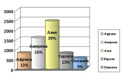
The graph shows which continents are most often the epicenter of natural disasters. Asia is the most prone to cataclysms. The US is in second place. According to geologists, North America may soon disappear from the face of the earth due to.
Natural disasters
The statistics of natural disasters over the past 5 years shows their 3-fold increase. According to scientists, more than 2 billion people have suffered from natural disasters during this time. This is every third inhabitant of our planet. Tsunamis, hurricanes, floods, droughts, epidemics, famine and other disasters are increasingly happening on earth. Scientists call the following causes of natural disasters:
- human impact;
- military, social and political conflicts;
- release of energy into geological layers.
Often the cause of disasters are the consequences of cataclysms that happened before. For example, after a large-scale flood, famine may occur or an epidemic may begin. Types of natural disasters:
- geological (landslides, dust storms, mudflows);
- meteorological (cold, drought, heat, hail);
- lithospheric (volcanic eruptions, earthquakes);
- atmospheric (tornadoes, hurricanes, storms);
- hydrospheric (typhoons, cyclones, floods);
natural disaster statistics hydrospheric nature (namely floods) today in the world shows the highest rates:
The chart below provides data on how many cataclysms occur, and how many people have been affected or killed by each of them in recent times.

On average, about 50 thousand people per year die due to natural disasters. In 2010, the figure exceeded the threshold of 300 thousand people.
The following natural disasters occurred in 2016:
| date of | A place | Cataclysm | Affected | dead |
| 06.02 | Taiwan | Earthquake | 422 | 166 |
| 14–17.04 | Japan | Earthquake | 1100 | 148 |
| 16.04 | Ecuador | Earthquake | 50 000 | 692 |
| 14–20.05 | Sri Lanka | Flooding, landslides, rain | 450 000 | 200 |
| 18.06 | Karelia | Storm | 14 | 14 |
| June | China | Flood | 32 000 000 | 186 |
| 23.06 | America | Flood | 24 | 24 |
| 6–7.08 | Macedonia | Flooding and landslides | Dozens of people | 20 |
| 24.08 | Italy | Earthquake | n/a | 295 |
The BBC is constantly creating documentaries about natural disasters. They colorfully and clearly demonstrate what is happening in the world, what disasters threaten humanity and the planet.
If the government of each country takes measures to provide for the population and prevent some disasters that can be predicted in advance, then cataclysms will occur less often. At least number negative consequences, human casualties and material losses will be much less.
Data for Russia and Ukraine
Cataclysms occurred in Russia often. As a rule, they marked the end of the previous era and the beginning of a new one.
For example, in the 17th century, major disasters occurred, after which a new era began, more cruel. Then there were raids of locusts that destroyed crops, a great eclipse of the sun, the winter was very mild - the rivers were not covered with ice, which caused them to burst their banks in the spring and floods occurred. Also, the summer was cold, and the autumn was hot, as a result, in mid-December, the steppes and meadows were covered with greenery. All this led to the fact that there were prophecies about the coming end of the world.
As the statistics of cataclysms show, thousands of people die and suffer from them every year in Russia. Disasters cause losses to the country in the amount of up to 60 billion rubles. in year. Most of all cataclysms are floods. Second place is occupied by tornadoes and hurricanes. Between 2010 and 2015, the number of natural disasters in Russia increased by 6%.
Most of the disasters in Ukraine are landslides, floods and mudflows. Since there are a huge number of rivers in the country. In second place in terms of destructiveness are fires of forests and steppes, strong winds.
In April 2017, the last cataclysm in the country occurred. A snow cyclone passed from Kharkov to Odessa. Because of him, more than three hundred settlements were de-energized.
in the world has been increasing in recent years. Some disasters are impossible to predict. But there are those that can be predicted and prevented. It is only a matter of ensuring that the leadership of each country takes adequate measures in time.