The Lena River: source, direction of flow, length, mouth. Brief description of the Lena River: location, hydrological regime and economic use
The Lena River is one of the eleven longest in the world, stretching for 4,400 kilometers from its source in Baikal mountains oh, that it is very close to Lake Baikal, to the mouth, where, dividing into numerous branches, it flows into the Arctic Laptev Sea. The total area of the river basin covers an impressive 2,490,000 square kilometers, and the delta, at 32,000 square kilometers, is the largest Arctic delta in the world.
This is hard to believe when you see the source of the Lena River, which is a small reservoir of water that does not have a name, at an altitude of just over a kilometer above sea level. Passing your long haul to the cold Arctic waters, the river gradually gains strength, being fed from streams and streams flowing into it. It becomes wider and deeper, like a Phoenix rising from the ashes, like a frog turning into a princess, appears in all its glory, demonstrating to everyone incredible strength, confidence, and finally, dissolving in the arms of a huge and chillingly calm northern sea.
Lena can be conditionally divided into three sections, 1,450 kilometers each: the upper part from the source to the confluence of the Vitim River, the middle section from Vitim to the mouth of the Aldan River, and the lower northern part from Aldan to the Laptev Sea.
In the first section, this river carries its waters among rocky steep slopes, in some places towering 300 meters above it. These rocks are the northern part of the Baikal Mountains. The width of the river bed ranges from 2 to 10 kilometers, narrowing in places in canyons to only 200 meters, the most famous of which, called the “Drunken Bull”, is located 237 kilometers from the city of Kirensk. In its first couple of hundred kilometers, the Lena is a rapid river, with a large number of rocky shoals that disappear after confluence with the Kirenga River. Below the mouth of the Kirenga, the depth of the river already reaches 9 meters and the flow rate is significantly reduced. In the middle section, the Lena becomes a calm and deep river, constantly increasing the water flow, especially after the confluence with the Olekma. The river gently bends around the plateau, forming a large bend, where the width of the valley increases to 32 kilometers. Below the Olekma, the nature of the channel changes dramatically. The Lena River flows along the bottom of a narrow canyon with steep, almost sheer cliffs that resemble the ruins of medieval castles.
Below the mouth of the Aldan, Lena enters the Yakut lowland, expanding the floodplain to 26 kilometers. In this place, the river receives one of its most important tributaries - the Vilyuy. The floodplain is replete with many swampy lakes, and the riverbed is divided into several branches, forming a huge delta. The depth of the river in this place reaches 20 meters, but there are also sections with shallows. IN winter time the Lena bed is covered with ice.
History
The origin of the name of the Lena River is said to come from the local Evenki word Elyu-Ene, which means " big river". The discoverers are considered a group of Russian hunters led by Pyanda, who first recorded the name "Lena River" in the 17th century. It should be noted that this version is not the only one, there are others. And only in 1885, an expedition equipped by the Russian Imperial Academy of Sciences explored the Lena River, from its source to the delta, and this became the beginning of its use as an important trade and transport route for transporting goods in the Arctic Ocean.

Modern meaning
This river plays an important role in the life of the people who settled along its banks. Where it flows through the plains, the cultivation of various crops is widespread, in particular wheat, barley, cucumbers and potatoes. Extensive pastures for grazing animals in the floodplain of the Lena River contribute to the development of cattle breeding. The surrounding lands are rich in a variety of minerals, including gold and diamonds, as well as iron ore and coking coal deposits, which are two key ingredients in steel production. Fields are being actively developed natural gas. It is clear that the Lena is a navigable river and is the most important transport artery of the region. Various cargoes, including minerals, furs, foodstuffs and industrial goods, move along the route through the Northern Arctic Ocean and often this is the only way to contact the rest of the world. The river has a huge potential for the development of hydropower, which is practically not used, which, however, is good for the flora and fauna of the Lena River.
Habitat
Differences in temperature conditions, topography and rainfall along the entire length of the Lena River, determine the diversity of vegetation different regions. The central valley has wide expanses of steppe, while the floodplain of the river at the source is characterized by coniferous forests typical of the taiga with its own peat bogs and swamps. Closer to the mouth, in the lower reaches of the Lena, the banks of the river are surrounded by spacious landscapes of the tundra, mosses and lichens begin to predominate, covering the ground in more northern regions. A huge number of birds, mostly migratory species, nest in these places. In summer, the fertile wetlands of the Lena River Basin become home to geese, swans, waders, birds of prey and many other types. Arctic lamprey, omul, grayling, whitefish, taimen, burbot, pike are some of the 38 species of fish inhabiting the waters of the river, and food base they serve 92 planktonic species living in it.

Ecology
The river, called the Lena, is still one of the most clean sources fresh water on our planet. In addition, it flows in a natural channel, since the length of the river near the Lena basin is not blocked by dams and reservoirs, and this distinguishes it from other large rivers of Siberia. But, unfortunately, there are other threats to the ecosystem, about 25,000 tons of oil from the Lena River enters the Arctic Ocean every year, threatening the existence of many species of flora and fauna. Though large areas river basins are protected by nature reserves and protected areas, depletion of fish stocks, uncontrolled deforestation and excessive water withdrawal for irrigation of arable land are sad realities of today.
The Lena River, one of the largest rivers in Russia and the world, did not get its name from the name of someone's wife or daughter. Contrary to conjecture, scientists believe that the river was named by the Evenki and sounds like “Eluene”, which eventually transformed into the name “Lena”, which is more familiar to Russian people.
As is common among all the peoples of the world, the name of the region's largest watercourse is easily translated and means "Big River" or "Big Water".
Description
The description of the Lena River should begin with the fact that it is the largest in Central Siberia. According to accepted data, its length is approximately 4400 km - it literally "cuts" the entire territory of the country from the southern borders to the coast of the Arctic Ocean. At the mouth, the river forms a large branched delta, which occupies an impressive area. 
By all its characteristics, this majestic watercourse can be classified as one of the largest on the planet. Thus, the Lena River basin is approximately 2 million 490 thousand km 2. In other words, it feeds on water that flows from an area 4 times larger than the area of France. Tributaries of various sizes enter the main channel, providing full flow throughout. 
The important natural value of the river is as follows: it is the largest river in the world, which is located in the permafrost zone. This natural area characterized by fragility and susceptibility to various disturbances, deformations, and the presence of such a large watercourse is an example of a unique landscape. Located in the extreme zone low temperatures one feature is also connected: the river freezes from the lower parts (mouth) towards the upper reaches, and opens during the melting of ice in reverse direction.
Location
The Lena River on the map of Russia is the central artery of the country. IN geographically it is the "heart" of the country and pass by it on the way from the European part of Russia to Far East just impossible.
During its course, the Lena crosses several large subjects of the federation: the Irkutsk region, the Republic of Sakha (Yakutia). As for the tributaries, they originate in the Trans-Baikal, Krasnoyarsk and Khabarovsk Territories, as well as in the territory of Buryatia and Amur region. Such coverage of the geography of the Asian part of Russia determines the greatness of the reservoir. 
The Lena River on the map is a relatively straight line that stretches in the meridional direction. The direction of the flow from south to north makes it huge not only for its natural significance, but also for its economic potential, which will be discussed below.
The geographical position of the Lena River has stimulated constant interest from scientists and researchers who have studied the river from all sides. At the same time, the situation in wild, remote places significantly limits the development of the channel.
Finding on the map where the Lena River is located is not difficult - such water artery immediately attracts attention.
Source
The source of the Lena River is presumably located on the western slope of the Baikal Range. The height of the source of the Lena River is approximately 920 meters, although this figure varies in different sources. Lena originates 10 kilometers from Lake Baikal, in an overgrown lake. After a long search for the source, its coordinates and exact location were established, which was fixed in 1997 with a kind of monument to the Lena River - a small chapel was built at the source. 
In the initial section, the nature of the flow of the Lena River is mountainous, because the channel cuts through the mountain ranges of Transbaikalia and enters Yakutia already with a flow rate of 1100 m 3 / second.
It is in the middle reaches that the two largest tributaries, Aldan and Vitim, come into the watercourse. The tributaries of the Lena River vary greatly in size. To these two, mention should be made of the Olekma and Vilyui, which are also fairly large rivers. Throughout the river, tributaries of various sizes enter the watercourse, which feed the Lena. Already in the middle reaches, the river becomes full of water.
Where does Lena go?
From the moment of studying Siberia and the Arctic Ocean, it was known into which sea the Lena River flows. It carries its waters to the Laptev Sea, where the Lena flows into in the area of the Bulunsky ulus. 
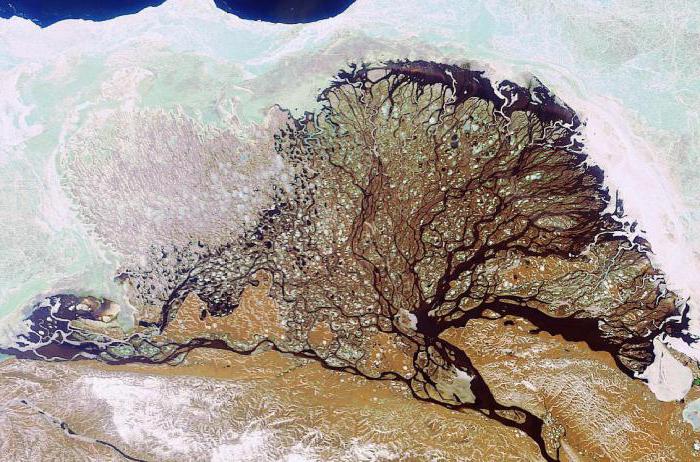
As mentioned, the mouth of the Lena River passes into a huge delta, which begins about 150 kilometers from the confluence with the Laptev Sea. The ramifications are of different sizes and in most cases are perfectly passable for ships. Such characteristics make the port of Tiksi, which is located at the mouth, one of the most attractive objects for navigation. 
In addition, the delta itself is an important natural object, which is almost completely occupied by a reserve and a special reserve. The natural heritage of the region makes it one of the most picturesque and valuable regions of the planet.
Nutrition and mode
The volumes of the river's annual flow vary greatly in existing sources, which is associated with insufficient observations and the complexity of the work of the river itself. So, you can find the values according to which the Lena carries out into the ocean from 485 to 545 km 3 of water per year. 
The nutrition and regime of the Lena River are determined by its beginning and flow in the permafrost zone. Main source water - melted and rain water. The snow diet determines the seasonality in the water level in the river, the peak of which falls on late autumn when the snow melt reaches maximum values. It is the type of nutrition of the Lena River that contributes to high water content - the collection of melted snow from such a large area helps to maintain constant high level water in the stream.
Every year in Siberia there is a long and Cold winter. During this period, a thick ice cover forms on the river. In the spring, at the moment of the beginning of its movement, on different areas The formation of serious ice jams, which often lead to flooding of the territory, can be noted. For emergency services, this is a serious problem and requires constant monitoring of the state of the ice. 
The fall of the river (the difference in the heights of the source and mouth) is about 1500 meters. Thus, the overall slope of the Lena is 0.33 meters per kilometer, which is quite high for a flat river. Most of The current passes through the Central Yakut Plain. The maximum depth of 21 meters was noted along the channel.
The floodplain formed by the river is quite wide and is up to 20 kilometers. In some areas, for example, at, pronounced terraces can be distinguished. These riverside relief elements are covered with characteristic ridges formed from reclaimed sand. In some places you can find preserved lakes-old women.
Economic importance
The economic significance of the Lena River is determined by its full flow and accessibility for river navigation. Considering the remoteness of the territories and a high degree isolation, we can assume that the river serves as the main transport artery that connects the vast expanses of Yakutia and Transbaikalia with the federal transport network. In different parts of the river, the nature of the movement along it differs. So in the upper reaches it is difficult to navigate on large ships, for which there are many difficult sections of the channel. In the middle and lower reaches, rafting is possible on large river vessels, which deliver cargo to large river ports and to the main sea bay - the village of Tiksi. 
The right and left tributaries of the Lena are also actively involved in transport system. They carry out the delivery of goods of various sizes to the central channel. On all coasts there are small ports and moorings that are involved in the movement of goods.
On average, the navigation period on the river is 130-170 days.
The channel itself is practically not changed by man, which is due to the inaccessibility of the region. There are no dams and hydroelectric power stations, which makes the river extremely clean. In the upper reaches, you can safely drink water directly from the riverbed.
Several large bridges are thrown across the river, which play important role in communication between regions. Not so long ago, a new concrete road bridge was built near the village of Ponomarevo. There is an old bridge in Ust-Kut and a pontoon bridge near the village of Zhigalovo. There is also a large railway bridge in Ust-Kut.
Many interesting facts are connected with the Lena River.
- For most of its course, the river is completely uninhabited. It flows through abandoned villages and dense coniferous forests. The territories are completely virgin and untouched by man, which makes the landscapes especially unique.
- Below Kirensk are the famous. Today, this natural treasure is carefully protected, while it is open to tourists who have made the pillars a "Mecca" for rock climbers.
- During high water in some areas, the level of the river can rise by more than 10 meters.
Lena river this is the largest Siberian river. By world standards, it is rather big. The Lena is the tenth longest river in the world. The length of the river, from source to mouth, is 4,400 km. The area of the catchment basin is 2,490 thousand sq. km. The main food of the river comes from melt and rainwater. It flows through the territory of Yakutia in Irkutsk region.
Where does it run: The source of the Lena River is located near Lake Baikal, on the Baikal Range. The height of the source above sea level is 1470 meters. It is from here that the largest river in Siberia originates from a small swamp. IN upstream Lena flows through the mountainous Cis-Baikal and its channel is relatively narrow. The middle course is a segment between two tributaries: Vitim and Aldan. In the middle reaches, this is already a large deep river, with a depth of up to 20 meters. Coniferous forests grow on both banks. After the city of Yakutsk, two more large tributaries flow into the river - Aldan and Vilyui. Lena turns into a truly gigantic stream. Its width is 10 km, and sometimes it spills over 30 km. Further, the riverbed is sandwiched between mountains and ridges, which do not allow it to overflow. At the mouth, the river forms a vast delta with many branches and flows into the Laptev Sea.
Characteristics of the Lena River.
The length of the river is 4400 km.
The catchment basin area is 2,490,000 sq. km.
The maximum width of the floodplain is 30 km.
Max Depth- 21 m.
Fall - 1470 - 0 = 1470
Slope: 1470 divided by 4400 (fall per length)=0.33 m/km or 33 cm/km
Nutrition: the river is fed mainly by melt water, in the upper reaches - glacial nutrition.
Large tributaries: Olekma, Aldan, Vitim, Vilyui.
Biological resources, inhabitants: kondevka, nelma, omul, muksun, burbot, taimen. In the upper reaches there are: lenok, dace, pike, grayling, perch.
Freezing: late October, early November. Opening occurs in the upper reaches from late April to mid-May, in the lower reaches - in early June.
The regime of the river is characterized by spring floods and several high floods in summer. In autumn and winter - low water. Ice drift is often accompanied by ice jams and is characterized by great power.
Economic use of the Lena River.
Lena is one of the most clean rivers peace. The course of the river has not been changed by man. On the this moment no dams, hydroelectric power stations, or other structures have been built on the river. In uninhabited places, you can still drink water straight from the river.
Since there are not many settlements on the banks of the river, economic use it is not carried out very intensively. This makes it possible to keep unique nature. As mentioned above, no dams, etc. have been built on the river, but Lena, nevertheless, is the main transport artery of Yakutia. Shipping starts from the Kachug pier. Unfortunately, before the confluence of the Vitim, the river is not navigable.
Major ports: Osetrovo, Kirensk, Lensk, Yakutsk
Environmental problems.
Scientists from the University of Alaska, the Institute of Permafrost Science of the Russian Academy of Sciences, the National French Center scientific research established that global warming negative impact on the river. In these parts in winter, the temperature drops to -70 degrees, and the permafrost is one and a half kilometers. Scientists have found that over the past 40 years the air temperature has risen by 4 degrees. Floods, already very strong, are only gaining strength every year, which destroys the banks of the river. Besides. the islands move down the river. In 2009, the speed of their descent reached 27 meters per year.
Lena? What are the features of its hydrological regime? Where is the source of the river? Lena is one of the largest river systems on the planet, the eighth in terms of fullness and length of all existing ones. It will be discussed in our article.
Unique features of the river
The Lena is one of the largest river systems in Asia and the world. The total area of its basin occupies about 20% of the territory of Russia. Width reaches colossal proportions- about 15 km in the middle reaches and up to 20-25 km in the lower. Major tributaries Lena - Aldan, Vilyui, Olekma and Vitim. By the way, the length of the latter is quite comparable with the length of such major European rivers as the Dnieper or the Danube.
Where is the source of the river? Lena is an amazing geographical formation. The watercourse boasts several records and surprises many interesting facts. So, very few people know that only twenty kilometers from Lake Baikal is the beginning of the river. Lena carries its waters in a northerly direction, to the coldest ocean in the world. so big that it is listed in the Guinness Book of Records!
Among other things, the Lena is one of the cleanest watercourses in the world. There are no dams or power plants on the river. In many parts of its channel, you can, like two thousand years ago, drink water by simply scooping it up from the river with your palm. Lena is one of the largest and most important sources of fresh water on our Earth.
Coordinates and height of the source of the river
Lena begins on the western slope By the way, at about the same latitude, but only on the other side of Lake Baikal, the Vitim also originates - one of the largest tributaries of this river system. What are the exact coordinates of this place? Where is the source of the river?
Lena is born in the mountains. Approximately 20 km from west coast Baikal is a tiny mountain lake. His exact geographical coordinates: 53° 59′ 33′′ northern latitude and 107° 53′ 01′′ East. It is from this lake, as is commonly believed, that the Lena flows. Near the source of the river, a small chapel was built with a corresponding information plate.

1470 meters above sea level - this is exactly the height of the source of the river. Lena, largest river Siberia starts right here. It is curious that this outstanding lake, which gave the world such an important river, does not even have its own name. I would like to hope that in the near future he will still have his own name.
Hydrological regime and nature of the river
Lena, like all its tributaries, is fed by rain and melt snow waters. The river is characterized by spring floods and a number of powerful floods in summer and spring time of the year. Lena has one very interesting feature. Due to the large length of the river from north to south, its channel begins to freeze from mouth to source. Lena opens in the opposite direction - from the upper reaches to the delta.
Geographers conditionally divide the river into three parts:
- the upper reaches (before the confluence with the Vitim);
- the middle course (before the confluence with the Aldan Lena);
- downstream.
In its upper reaches, the Lena has the character mountain river: meandering channel, rapid current, an abundance of rocks and rapids. The shores here are high and steep, they are occupied by pine, fir and spruce forests.
Taking in the water becomes much fuller. Here Lena is directed to the east, and only in the area of the city of Yakutsk does it change its azimuth strictly to the north. The depth of the river in the middle reaches reaches 10-12 meters. The channel here expands significantly, and in it appear small islands, busy conifers. In this one, it confidently cuts through the limestone Prilensky plateau, after which it enters the vast flat expanses.
Lena in its lower reaches is already a powerful watercourse, the width of which exceeds 10 km, and the depth reaches 20-30 meters. The river banks here are cold and deserted, there are practically no settlements. Approximately 150 kilometers from the vast delta of the Lena begins. The area of this unique natural education is 45,000 sq. km.
Attractions and tourism potential
It is very difficult for a tourist not to fall in love with the beautiful Lena. This amazing river conquers everyone with its fantastic landscapes, the purest water and the richest fish world. Here you can often see pleasure boats with numerous tourists and sightseers.
Of course, the main and most famous attraction of the river is the geological monument of nature - the Lena Pillars. This incredibly beautiful formation is located on the right bank of the Lena in Yakutia. The nearest city is Pokrovsk.

Huge rocky pillars up to 220 meters high hang over water surface rivers. For millions of years, two tireless craftsmen, wind and water, have been working on these blocks of sandstone. In 2012, the Lena Pillars were included in the List world heritage UNESCO.
Conclusion
Where does it flow, what features are characteristic of Lena? Where is the source of the river? The Lena is the great river of Siberia, flowing from a small lake in the Baikal mountain range. Further, it overcomes a distance of 4400 kilometers and flows into the Arctic Ocean, forming a huge delta in area.
One of the longest rivers on our planet is the mighty Lena River. The river is fed by rain and melted snow. The flood happens in springtime. Since Lena is located in the northern part of the territory Russian Federation, then because of the permafrost, the river cannot be fed with groundwater. Unlike other rivers in Russia, the Lena is characterized by strong freeze-up. In the spring, the ice drift is especially strong and jams often form, due to which serious floods occur. In spring, the water level can rise to almost ten meters.
It is impossible to imagine the northern expanses of the country without a beautiful river. coniferous forests and the dense taiga stretched their expanses along the banks of the Lena. It is thanks to her, and several other mighty rivers, that Russia is considered one of the richest states in the world. The river gives its state diamonds, gold and furs.
Length of the Lena River

Lena takes its origin not far from Lake Baikal. Heading towards Yakutsk, makes a big detour and moves to the northern regions of Russia. The Great Lena has a length of more than 4,000 kilometers. It flows through the Irkutsk region, then goes through the Lensk, Olekminsk urban districts, as well as through the regions of Yakutia. The maximum depth is 22 meters.
Source of the Lena River

(Source great river starts from a small lake in the cozy region of Baikal)
A small lake adjacent to Baikal is the source of the Lena River. A small body of water that gives life to a mighty river, currently has no name. The lake is located ten kilometers from Baikal, and rises almost 1,400 meters above sea level. In other words, Lena takes its source in a small mountain reservoir that does not have a name, which is located on the territory of the Baikal Range.

A small church was erected not far from the beginning of the river. Many tourists come here to see the source of the Lena, and also enjoy the surrounding picturesque views. Shishkinsky mountains are the most famous places in the upper reaches of the river. On the ancient rocks, drawings have been preserved to this day primitive people who have historical meaning. Here you can see the depicted scenes of sacrifices, hunting and other rock "scene" of the ancient peoples. It is these places that are the most extensive areas where you can get a broad idea of the life of primitive settlements.
Tributaries of the Lena River

(View of the tributaries of the Lena River)
Most of the river's tributaries belong to the Krasnoyarsk, Khabarovsk, Trans-Baikal Territory and Buryatia. The left tributaries include the Anai, Nyuya, Kuta, Turuk, Kukhta, Upper Kytyma and others. And to the right tributaries - Anga, Chichapta, Kirenga, Turtle, Big Patom and many others. The main tributaries are the Aldan, Vilyui, Vitim and Olekma. The Vilyui tributary is considered the largest and longest tributary of the river from its left tributaries.
Mouth of the Lena River

(The Lena River receives a tributary of the Vilyuy River)
Having passed its way through Yakutsk, the river receives two main tributaries - Vilyui and Aldan. Now it's not calm river, but powerful water element with a width of up to 21 km, and a depth of more than 20 meters. The banks of the Lena in these places are very dangerous. Here are small settlements. The water avalanche moves and flows into the Laptev Sea. Approximately 100 km from the sea, the river transforms into a huge delta, consisting of 780 tributaries and islands of various sizes. Three main channels of the river reach the sea - Olenekskaya, Trofimovskaya and Bykovskaya. Vessels that are of great industrial importance for the whole country go along the canals. The picturesque delta impresses with its flora and fauna. Here you can meet rare plants and more than 120 different types birds.
Cities of Russia on the Lena River

(Ice-covered Lena near Pokrovsk)
The banks of the Lena do not serve as a home for a large number large cities of Russia. Most of the settlements are located in the Yakutsk region. Today, many villages are empty or serve as a place for shift camps. But, nevertheless, Pokrovsk, Siktyak, Kyusyur, Chekurovka and some other settlements founded their houses on the banks of the river.

(The famous Lena Pillars)
The unique Lena Pillars are located in the Khaagalassky district. Picturesque nature Park contains a lot of interesting things for every guest of these places. Two historically important settlements spread their expanses on the banks. Sottintsy and Zhigansk. Sotnitsy is the original foundation of Yakutsk. There are cruises on the Lena River, boat rides and trips to local attractions. Lena also presents a lot of other entertainment, so many travelers prefer to relax on the banks of the mighty Lena.
The Lena River in folk culture
Many historians believe that Vladimir Ulyanov named himself Lenin in honor of this powerful element. The river has great value for every inhabitant of its shores. locals compose songs and poems in honor of the river-nurse, paint pictures. The beauty of river landscapes is sung by many world poets. Lena is also immortalized on some famous canvases of artists. The power and greatness of Lena also inspires our modern creators.