What countries are in East Africa. The easternmost point of Africa. East African countries
East Africa - a subcontinent located in the east of the mainland, unites two physiographic countries: the Ethiopian Highlands and the Somali Peninsula and the East African Highlands (plateau). The region is elongated in a submeridional direction (between 18° north and south latitude). It begins in the north near the southeastern margin of the Sahara, in the west it has fairly clear orographically determined boundaries with the regions of Northern and Central Africa, in the south it is separated by a system of faults from similar structures in South Africa, reaching the tectonic valley of the lower reaches of the river. Zambezi. In the east, the subcontinent faces the Indian Ocean and its seas.
The subcontinent is located in the most tectonically active part of the African platform in the development zone of the grandiose complex system continental rifts, unparalleled both in length and amplitude of vertical movements.
East African rift zones occupy a special place in shaping the nature of the region. They are associated with features of the relief, predominantly mountainous and plateau, the widespread development of volcanism, including modern, and increased seismicity. Rifts are expressed by grabens, the bottoms of which are often occupied by lakes.
The region is located in the zone of action of the equatorial monsoons of both hemispheres. A characteristic feature of its climates is the extreme differentiation of moisture conditions not only by seasons, but also within the territory. To a large extent, this depends on the fragmentation of the relief and the configuration of the coastline.
- East Africa is characterized by a great variety of soil and vegetation cover - from evergreen tropical rainforests on windward mountain slopes to the desert landscapes of the Afar Basin.
- Large areas are occupied by savannas different types. Altitude zonality is expressed in the mountains.
- East Africa is the main watershed of the mainland. From here originate the rivers of the Indian Ocean, the Mediterranean Sea and river system Congo, carrying to the Atlantic.
- The fauna of the subcontinent is very rich and diverse: all the main representatives of the fauna of the African savannas live here.
- East Africa is an area of fairly dense settlement and long-standing agricultural land use.
- The subcontinent has large reserves of minerals. In connection with human activities, the nature of the subcontinent has been significantly changed.
- East Africa is regarded as the ancestral home of man. Perhaps it was here that the species Homo sapiens arose as a result of the evolution of ancient primates.
Ethiopian Highlands and Somali Plateau
This physiographic country includes the Ethiopian highlands, the Afar depression, the plateau and the coastal lowland of the Somali peninsula. In the west, the region borders on the White Nile Basin, in the south - on the East African Highlands, in the north and east it goes to the Red Sea, the Gulf of Aden and directly to the Indian Ocean. Ethiopia, Somalia and Djibouti are located on its territory, in 1993 Eritrea separated from Ethiopia.
As a result of active tectonic movements, a very diverse and even contrasting relief was formed here. The main part of the region is occupied by the Ethiopian Highlands, which is a highly elevated block of the African Platform within the Eritrean anteclise (Nubian-Arabian arch), almost bounded by faults on all sides.
The height reaches 3000-4000 meters, the highest point is Ras Dashan (4623 meters). The steep stepped slopes of the highlands make it difficult to access, which is why it is often called a bastion massif. Fissure eruptions of trachyte and basalt lavas occurred along the fault lines. Covers were formed, having in some places a thickness of up to 2000 meters. Stepped lava plateaus - ambas are typical for the relief of the highlands. Cut in all directions by deep erosional-tectonic valleys-canyons, the ambas look like flat-topped remnants with separate volcanoes. Some of them have been active in historical times. Faults define the lines of the coasts of the Red Sea and the Gulf of Aden, limit the subsidence zone - the Afar depression. Its bottom, covered with lavas, is a low plateau with isolated volcanic cones. Separate basins lie below sea level. Lake Assal is the most low place African mainland (-153 meters). The Ethiopian graben in the south separates the highlands from the plateau of the Somali Peninsula, they descend in steps to the southeast to the Indian Ocean. The lower step is a wide, low-lying coastal plain. The eastern margin of the peninsula is also bounded by a fault, along which the ocean floor subsided.
In general, the climate of the country is subequatorial, variable humid, but the fragmentation of the relief determines the diversity and contrast of the climatic conditions of the region. Local factors of climate formation play here no less a role than general regularities.
Precipitation is mainly associated with the summer equatorial monsoon of the southwest direction. Most of the moisture (1000 mm per year or more) is received by the windward southwestern and western slopes of the Ethiopian highlands. The northern slopes are under the influence of tropical air. They are dry. Most of the Somali peninsula receives little rainfall (250-500 mm per year). Even on the coast of the Indian Ocean, the climate is arid, as the flow of the southwest monsoon moves along the coastline here. The driest areas are the Ethiopian graben, the coasts of the Red Sea and the Gulf of Aden, and especially the Afar depression. The entire region, except for mountainous areas, is characterized by high air temperatures: average monthly temperatures are not lower than 20°C, maximum temperatures are up to 40-50°C. The Afar depression is one of the hottest places: the average January there is 24 ° C, the average July is 36 ° C. The Ethiopian highlands are much cooler. Altitude climatic zonality is traced here:
- colla belt (hot) - up to a height of 1500-1800 meters; average monthly temperatures - 20°C and above, the amount of precipitation on the windward slopes - 1000-1500 mm per year;
- war-degas belt (moderate) - up to a height of 2400-2500 meters; small seasonal temperature fluctuations: in December - not lower than 13°С, in April (the warmest month) - not higher than 16-18°С; precipitation - 1500-2000 mm per year;
- degas belt (cold) - on high mountain ranges; average monthly temperatures do not exceed 16°C, in winter there are very coldy, snow falls; however, there are no glaciers.
Thus, the region combines dry and hot climates of low plains, humid and cool climates of highlands and plateaus, humid and hot climates of the Kolla mountain belt and adjacent flat areas.
The river network is well developed in the Ethiopian highlands. Here originate one of the sources of the Nile - the Blue Nile, the right tributaries of the White Nile - Sobat and the Nile - Atbara, Omo. The Blue Nile carries twice as much water into the main river as the White Nile. Its runoff is regulated by Lake Tana. There are small lakes at the bottom of the Ethiopian graben. On the Somali Peninsula, the river network is poorly developed, most of the rivers dry up, and in the Afar depression surface runoff practically absent, there are only a few small salt lakes. The river flows into one of them. Avash flowing down from the highlands.
The complex structure of the relief and the contrasts of climatic conditions determine the diversity of the vegetation cover of the Ethiopian-Somali region. In the Ethiopian Highlands, altitudinal zonation is exceptionally pronounced.
Dense evergreens grow on the damp western slopes in the colla belt and in deep valleys with good moisture. rainforests, on species composition and structure close to equatorial. The watershed plateaus are occupied by savannahs. Thickets of thorny bushes and xerophytic light forests dominate on dry leeward slopes. The War-Dega belt was once dominated by forests of cedars and yews, which have been largely cut down. The thickets of tree-like juniper and woodlands of deciduous trees - wild olive and fig tree - are better preserved. The main part of the belt is currently occupied by a mountain savanna with candelabra-like spurges, umbrella acacias, giant sycamore trees and a rich grass cover of cereals. Coniferous forests of junipers, podocarpus, etc. grow in the lower part of the degas belt. Above, mountain meadows predominate - grasslands with groves of the kusso tree and individual tree-like junipers. Thickets of giant St. John's wort, tree-like heathers, and communities of xerophytic bush grasses appear even higher. The uppermost parts of the mountains are covered with rocky placers, which are covered with snow in winter. In the Afar depression and on the coasts of the Red Sea, the Gulf of Aden and the Indian Ocean, semi-desert and desert vegetation is developed. The interior plateaus of the Somali peninsula are dominated by landscapes of deserted savannahs.
The fauna is common for the savannas and tropical forests of Africa, including mountainous ones.
In the War-Dega belt, there are monkeys that cannot tolerate constant heat - hamadryas, Gverets, Geladas. The fauna of the region has a relatively high degree of preservation even outside protected areas. So, elephants live in the forests of the lower belt of mountains, and this is one of the few places where they do not live in reserves.
The Ethiopian highlands have significant agro-climatic and land resources. Its territory as a whole receives sufficient rainfall for agriculture. Particularly favorable conditions for the cultivation of valuable crops and for the life of people in the war-degas belt with its relatively cool, constantly humid climate and fertile dark red and chernozem-like soils.
Most of the Ethiopian population lives here. This is one of the ancient centers of agriculture. They grow cereals, tobacco, oilseeds, citrus fruits, and grapes. The name of the belt, translated from the language of local peoples, means "grape zone". This belt is considered the birthplace of the coffee tree. In the south and southwest, coffee plantations rise up to 2000 meters. Some cereals also come from here - durum wheat, rye, barley, etc. Only some flat valleys are waterlogged, swampy and unfavorable for life. In the Kolla belt with a hot, humid climate, the population is sparse, but in some places there are plantations of coffee, cotton, and sugar cane. Cattle breeding is developed in dry regions. Cattle breeding (zebu, sheep, goats) is also carried out by the inhabitants of the degas - the cold zone, and only in its lower part, up to a height of 2800 meters, local teff cereal is grown. At the lower boundary of this belt at an altitude of 2440 m is the capital of Ethiopia - Addis Ababa.
The arid territories of the Somali peninsula are not very suitable for agriculture. The population is concentrated in river valleys and oases, where commercial tropical crops are grown on irrigated lands: bananas, sugar cane, cotton, date palm, and for own consumption - cereals and legumes. Most of the population is engaged in cattle breeding. In many places in Afar, desert coasts, the interior of the Somali plateau, even in wells, the water is brackish. There is practically no settled population. In the arid regions of this region, well-preserved bone remains of animals have been found, including ancient primates, which are considered human ancestors.
Large reserves of ore minerals are concentrated in the bowels of the region. There is gold, platinum, ores of copper, nickel, manganese, iron, niobium, uranium and thorium. There are also deposits of piezoquartz, potassium and table salts, native sulfur, mica, and gypsum. But only a small part of this wealth is used.
The main problem in the region is the lack of water in many parts of it. There are severe droughts that cause famine. Drought in the 70s 20th century in Somalia led to a huge reduction in the number of livestock and the death of a large number of people. Drought control is one of the most acute problems in the region. Despite the fairly good preservation of the fauna, many species of animals have been severely exterminated and are even on the verge of extinction. For their protection, several national parks and reserves have been created in Ethiopia and reserves in Somalia. They protect not only animals, but also typical and interesting landscapes, for example, in the territory of Awash Park, where there are manifestations of volcanic activity. Palm forests around hot springs and riverine gallery forests are subject to protection.
East African Highlands
Most of this physiographic country is located in the Southern Hemisphere. In the north, the East African Highlands borders on the Ethiopian along the faults in the area of Lake Rudolf, to the south it extends to the valley of the river. Zambezi. The western border with the Congo basin runs along the watershed between the rivers of the Congo basin and the African Great Lakes. In the east, the region faces the Indian Ocean. Within its boundaries are Kenya, Uganda, Rwanda, Burundi, Malawi, Tanzania and northern Mozambique. In many features of nature, this physiographic country is similar to the Ethiopian highlands. Tectonic mobility, fragmentation of the relief, manifestations of ancient and modern volcanism, subequatorial climate with sharp internal differences, a variety of landscapes dominated by savannah formations determine the similarity of these regions. The rift zones of the East African Highlands are genetically related to the Ethiopian graben, which, in fact, is their continuation to the north. However, the region has a number of natural features that distinguish it from the Ethiopian-Somali country.
With no less tectonic mobility than in the Ethiopian Highlands, the areas of lava covers are not so large in the East African Highlands. There are volcanic massifs, often of considerable height: Kilimanjaro (Kibo peak - 5895 meters, the highest point of the mainland), Kenya (5199 meters), Meru (4567 meters), Karisimbi (4507 meters), Elgon (4322 meters), etc. Among the large and there are many active small volcanoes.
The highlands are located within the anteclise of the ancient African platform with outcrops of crystalline rocks, in some places overlain by continental sediments and lava covers. In the Cenozoic, the rising dome of the anteclise was broken by rift faults. There are three branches of continental rifts. The western rift runs along the entire western margin of the highlands. Within its limits, a system of grabens is formed - from the graben occupied by the valley of the river. Albert Nile, in the north, to the tectonic valley of the lower reaches of the river. Zambezi. Most of them are a chain of narrow, long and deep lake basins (the bottom of Lake Tanganyika lies more than 600 meters below sea level). Between them and along the sides of the grabens there are horst and dome uplifts with an average height of 1000-3000 meters. As a rule, active volcanoes are associated with them. Between the lakes Albert and Eduard rises the Rwenzori massif (Mountains of the Moon), reaching at its highest point - Margherita Peak - 5109 meters. The entire area is highly seismic. The central rift begins in the north with the basin of Lake Rudolf and in the south in the basin of Lake Nyasa merges with the western branch. Here, a flat-bottomed valley (the Great Valley, or Rift Valley) with steep slopes (“rift shoulders”) was formed in the graben. At the bottom of it are many small salt lakes. Within this zone eruptions of lavas occurred, and then the central type was formed, which, including the highest massifs of the highlands, rise along tectonic fissures. Calderas are also characteristic of this zone, including the famous Ngorongoro Crater with a diameter of 22 km. The eastern fault zone descends in fault steps towards the Indian Ocean and defines the rectilinear outlines of the coastline. The spaces between the rift zones are dominated by a flat-mountainous relief, more or less leveled, with remnant mountains and uplands.
The subequatorial climate of the highlands has its own characteristics.
In the southern part, winds with an eastern component dominate throughout the year, since the northeast winter monsoon northern hemisphere when crossing the equator, it does not change direction, dragging into the South African baric minimum. In the north, the southwest monsoon dominates in summer. Winter precipitation is orographic, so only the windward slopes of the mountains are irrigated. Humidification of different regions within the highlands is not the same. The highest amount of precipitation (up to 2000-3000 mm per year) is received by high mountain ranges. In the north-west and south-west of the country and on the mountainous coast south of 5 ° S. sh. falls 1000-1500 mm. In the rest of the highlands, the annual precipitation is 700-1000 mm, and in closed depressions and in the extreme northeast - no more than 500 mm. Due to the general high hypsometric level of the East African Highlands, in most of its territory, air temperatures are relatively low (monthly averages are not higher than 19-20 ° C). Only at low altitudes, mainly on the coast, they rise to 23-28°C. Annual amplitudes of average monthly temperatures are up to 5-6°C. There are frosts in the mountains above 2000 meters, snow falls at an altitude of 3500 meters, the highest peaks (Kilimanjaro, Kenya, Rwenzori) have ice caps.
The East African Highlands - the "roof of Africa" - is the highest region of the mainland and the main watershed of the basins of the Indian, Atlantic Oceans and the Mediterranean Sea. This is where the river starts. Nile, numerous tributaries of the river flow from here. Congo (Lualaba), r. Zambezi, a large number of rivers flowing into the Indian Ocean. The highlands are distinguished by one of the largest clusters of lakes on Earth. The African Great Lakes occupying grabens in the Western Rift Zone are elongated and great depths(Tanganyika - up to 1435 meters). They are usually flowing and fresh. In a vast tectonic basin outside the rift zones lies the second largest freshwater reservoir in the world - Lake Victoria. Large masses of water in large lakes have a significant impact on local climates. There are many salt lakes on the bottoms of the grabens in the Central Rift - Natron, Nakuru, etc.
Most of the highlands are occupied by typical savannahs and light forests.
In the most arid northeastern regions, the same plant groups are common as on the Somali Peninsula (desert savannas). Drainage basins of salt lakes are surrounded by salt marshes with halophytic vegetation. In the western regions with a humid climate, the lower slopes of the mountains and the coasts of lakes were occupied by hylaea, which are now replaced in large areas by mixed forests with an admixture of deciduous species and tall grass savannahs. Altitude zonality is expressed in the mountains. Among the belts, the “belt of fogs” with mountain hylaea (2300-2500 meters) and the belt of mountain meadows with giant lobelia and tree-like crossworts stand out. The nival belt starts at a height of 4,800 meters.
Nowhere in the world is there such a variety of large animals, especially the inhabitants of the savannas.
Antelopes, buffaloes, zebras, giraffes and other herbivores once densely populated the highlands. They were hunted large predators(lions, leopards, cheetahs, etc.). There were many elephants, rhinos, hippos, various monkeys. Prolonged extermination caused a strong decrease in the number of animals, some of the species are on the verge of extinction. Numerous national parks and reserves have been created in the countries of the region, in which the number of animals is regulated. Among the world famous parks are Virunga, Kagera, Mount Kenya, Kilimanjaro, Serengeti, Ngorongoro (a natural "enclosure" bounded by the slopes of the caldera), Nakuru, where 370 species of birds live near the lake, including giant flamingo colonies. Mountain gorillas live in the southern protected part of the Kivu Park.
Scientific research is being carried out in protected areas. The countries of the region receive solid income from foreign tourists who are attracted here by exotic fauna and flora, unusual landscapes, the possibility of sport hunting under licenses.
In addition to land, agro-climatic and biological resources, the East African Highlands has unique reserves fresh water, concentrated in the African Great Lakes, which are used both for water supply, and as transport routes, and as a source of fish. The subsoil of the region is rich: there is gold, diamonds, various ores, salts are mined, including sodium carbonate - natron.
The region is densely populated, but unevenly populated. Most people live on the shores of fresh lakes. Maasai pastoralists roam the savannahs of Kenya and Tanzania. Almost all landscapes of the East African Highlands have undergone anthropogenic changes.
East Africa
East Africa.
physical map.
East Africa, a natural country in the equatorial and subequatorial latitudes of eastern Africa, between the Ethiopian highlands in the north, the Congo depression in the west and the lower reaches of the river. Zambezi in the south. In the east it is washed by the Indian Ocean. within the limits V.A. includes Somalia, Kenya, Uganda, Rwanda, Burundi, Tanzania, Zambia, Malawi. In a broad sense, it also includes the Ethiopian Highlands and Ethiopia and Djibouti located within it. For relief V.A. characterized by the predominance of mountains and plateaus. Most of the territory is occupied by the East African Plateau (altitude over 1000 m), broken by tectonic faults (see). There is a complex combination of elevated basement plains, deep and narrow fault depressions bounded by ledges of blocky mountains, lava plateaus, and isolated volcanic cones. IN V.A. there are the highest (over 5000 m) peaks of the continent - Kilimanjaro, Kenya, Rwenzori. Coastal lowlands stretch along the coasts.
The climate is equatorial and subequatorial, seasonally humid, hot (at an altitude of 1500-2000 m - warm, higher - cool). IN V.A. The largest and most abundant rivers in Africa, the Nile, the Congo (Zaire), and the Zambezi, originate; there are many large lakes lying in discharge depressions (Tanganyika, Nyasa, Rudolph, etc.) or filling shallow depressions within the basement plains (Lake Victoria). The vegetation is dominated by various types of savannas and light forests, in high mountains there is a change of altitudinal zones (from the mountain-forest to the African varieties of the subalpine and alpine belt). Rich and varied wildlife V.A.(especially the fauna large mammals- elephant, hippopotamus, rhinoceros, zebra, antelope, etc.). Large national parks - and.

typical landscape East Africa(with umbrella acacia).
Encyclopedic reference book "Africa". - M.: Soviet Encyclopedia. Editor-in-Chief An. A. Gromyko. 1986-1987 .
See what "East Africa" is in other dictionaries:
East Africa- East Africa is a geographical term covering the countries of Africa east of the Nile, with the exception of Egypt. To them from ... Wikipedia
EAST AFRICA- the eastern part of Africa in equatorial and subequatorial latitudes. Most of the East Africa occupies the East African Plateau. The climate is hot, seasonally humid, with precipitation from 500 to 3000 mm per year. In Vost. Africa is one of the largest in the world ... ... Big Encyclopedic Dictionary
East Africa- — EN East Africa A geographic region of the African continent that includes Burundi, Kenya, Rwanda, Tanzania, Uganda, Ethiopia and Somalia, and also Mt. Kilimanjaro and Lake… … Technical Translator's Handbook
East Africa- the eastern part of Africa in equatorial and subequatorial latitudes. Most of East Africa is occupied by the East African Plateau. The climate is hot, seasonally humid, with precipitation from 500 to 3000 mm per year. In East Africa, one of the largest… encyclopedic Dictionary
East Africa- a natural country covering the eastern part of Africa in the equatorial and subequatorial latitudes between the Ethiopian plateau in the north, the Congo depression in the west, the lower reaches of the Zambezi in the south and the Indian Ocean in the east. Within V. A. completely ... Great Soviet Encyclopedia
East Africa- 1) British (see Great Britain) and 2) German (see Germany) ... Encyclopedic Dictionary F.A. Brockhaus and I.A. Efron
East Africa is a natural country in eastern Africa. Within the East. Africa located Kenya, Uganda, Rwanda, Burundi, Tanzania, Zambia, Malawi, Somalia, Ethiopia, Eritrea, Djibouti. Geography. Modern illustrated encyclopedia. Moscow: Rosman. Under… … Geographic Encyclopedia
East Africa- (East Africa) World War II After Aug. 1941 15 thousandth English. the garrison located in Somalia was forced to evacuate from the country, Gen. Wavell developed with gene. Sir William Platt and Sir Alan Cunningham plan for ... ... Encyclopedia of World History Battles
Italian East Africa- Africa Orientale Italiana colony ← ... Wikipedia
German East Africa- Deutsch Ostafrika Colony of Germany ← ... Wikipedia
Books
- East Africa: Tanzania, Not available. Africa is the largest continent of the Earth, which is washed on all sides by the waters of the oceans: the Atlantic, Indian and Mediterranean seas. Previously, the mainland was connected with Asia by the Suez ...
East Africa. Economic and geographical characteristics
Table of contents
- Introduction
- General information
- Geographical position
- Natural conditions and resources
- Region population
- General information
- Demographic situation
- Economy of East Africa
- General information
- Agriculture
- Transport
- External links
- Conclusion
- Bibliography
Introduction
East Africa is a region of the world distinguished on the one hand by magnificent natural resources and attractions, on the other hand, one of the poorest regions in the world. Most of the countries in the region have a clearly agrarian-oriented economy. The exception is Zambia, which has an export-oriented economy based on the mining industry (extraction and export of copper).
The region occupies a large territory. This area is home to a significant portion of the African population. Therefore, the task of describing and studying this region is of particular relevance.
Thus, the purpose of this work was to study and analyze the current economic situation in the region, taking into account the specifics of the spatial organization of both the resources of the economic system and the location of its main nodes.
General information
The East Africa region is located in the eastern part of the mainland and includes 10 states (Figure 1, Table 1) - Djibouti, Eritrea, Ethiopia, Kenya, Malawi, Seychelles, Somalia, Tanzania, Uganda, Zambia.
Table 1 - Composition of the East Africa region
The total area of the region is 4,561,190 km2. The region has a population of 153,741,344 (2005).
Geographical position
The region is characterized by a fairly favorable geographical position. IN economic terms the region is located among the states characterized by a rather underdeveloped economy. However, in relation to the main mineral resource bases, the region has a rather advantageous position - in the northeast (Arabian Peninsula) and west (Gulf of Guinea) there are the richest oil and gas deposits, in the south there is a continuation of Africa's largest copper belt. In terms of transport, the region occupies a fairly advantageous position - proximity to the Suez Canal and the Red Sea provides quite significant potential benefits. In geopolitical terms, the situation is somewhat worsened by the situation among the poor countries of Africa, which are characterized by an extremely unstable political situation.
Figure 1 - East Africa: composition of the region
Natural conditions and resources
Tectonic and geomorphological conditions. Mineral resources
Tectonic-geomorphologically, the region is heterogeneous. The Ethiopian Highlands (Ethiopia, Eritrea) is a highly elevated block of the African Platform, which is characterized by high tectonic fragmentation and a variety of landscapes due to a clear separation of structural and morphological regions and altitudinal zonality. According to the degree of potential development, the region is difficult to access and poorly developed. The Somali Plateau in the east of the region is much smaller and much less indented, greatly increasing the potential for development. The East African Plateau (Kenya, Tanzania, Uganda) is a mobile, tectonically active part of the African Platform. The greatest rift system and the greatest heights of the mainland are concentrated here. The region is characterized by extremely complex terrain and low scores potential development.
In terms of the availability of mineral resources, the region belongs to the medium-provided region. Fuel and energy resources ( natural gas, oil) are absent. The exception is deposits hard coal in southwestern Zambia.
Metallic minerals are represented sufficiently. Gold deposits are located in the south of Ethiopia, in the west of Uganda, in the south of Zambia. A separate link in the spectrum of metallic minerals is copper ore. Widely known and of international importance is the so-called Copper Belt of Central Africa, which ends in Zambia. In addition to deposits of high-quality copper ore, deposits of polymetals (cobalt ores, nickel ores) are confined to this belt.
Non-metallic minerals are represented by diamond deposits in Tanzania (the Mwadui deposit), table salt (the border between Eritrea and Ethiopia).
Climatic conditions and agro-climatic resources
The region is climatically located in the subequatorial zone (a zone of sufficient moisture in the west, insufficient moisture in the east of Tanzania). The far north of Ethiopia, Tanzania and Eritrea lies in the tropical arid zone (Figure 2).
In agro-climatic terms, the region is confined to the tropical zone, characterized by continuous vegetation of plants throughout the year (it can only be interrupted by a dry period for a subequatorial climate with insufficient moisture). tropical belt characterized by the possibility of collecting several crops per year. Most of the region is within the isotherm of the sum of the air temperature for the period with temperatures above 10С over 8000С. Under these conditions, heat-loving perennial and annual crops with the longest growing season (sugarcane, coffee, cocoa, cinchona, rubber plants, etc.) can be grown. The eastern part of Ethiopia and western Tanzania, as well as western Kenya and eastern Uganda are within the isoline air temperatures for a period with temperatures above 10 C from 4000 C to 8000 C. These areas belong to the subtropical agro-climatic zone and are characterized by the possibility of growing heat-loving temperatures with a very long growing season (cotton, late corn, olives, citrus fruits, tobacco, tea, sometimes date palm, etc. .).
Hydrological conditions and water resources
There are no major rivers in the region. However, small rivers, descending from the plateaus, develop a sufficiently high speed, which characterizes their hydropower potential as acceptable for the construction of hydroelectric power stations.
By availability water resources The region is considered to be rather poor. Ethiopia, Tanzania, Eritrea and Somalia are characterized by the availability of total river flow resources of 2.5 - 5 thousand m 3 per year, Kenya - 0.5 - 2.5 thousand m 3 per year. Zambia is characterized by the most favorable conditions for the provision of full river flow resources (10 - 25 thousand m 3 per year).
The region has the largest lakes on the mainland - Victoria, Nyasa, Tanganyika. The lakes have significant recreational potential, which is intensively used.
Vegetation and fauna. Land resources
The region is characterized by the presence of 3 natural zones - wet equatorial forests(west of the region), subequatorial forests and woodlands (Zambia, Malawi), wet savannas(along river valleys), typical savannahs (Ethiopia), deserted savannahs (Somalia, Kenya).
In connection with the above, the land resources of the region are mainly grazing (this is due to the large spread of savannahs). Fragmentary there are forests that do not have an industrial value. Land suitable for cultivation has a small distribution.
east africa economic geographical
Figure 2 - Climatic zones of East Africa
( I - equatorial climate; II - Subequatorial climate: 1a - with sufficient moisture, 1b - with insufficient moisture; III - tropical climate )
Figure 3 - East African Land Resources
Region population
General information
The population of the region is 153,741,344 people (2005). The average population density is 33.7 people. / km 2. The largest population is typical for Kenya - 53,142,980 people, the smallest - for the Seychelles (73,000 people (2005).
Table 2 - Population density in East African countries
The highest population density is typical for the Seychelles, which is associated with a small area of the state. The average indicators for states are small and poorly reflect the real situation.
Demographic situation
Birth rates in the region are quite high. The northern states of the region are characterized by birth rates from 40 to 45 ‰, for the southern states - from 45 to 50 ‰. At the same time, mortality rates are also high - from 15 to 20 ‰. The natural increase in the population of the region for southern countries region is more than 30‰, for the northern - 25 - 30‰.
In the age and sex structure, women predominate, only in Kenya and Uganda there is a predominance of the male population.
Ethnic structure of the population
The southern part of the region is inhabited by the peoples of the Niger-Kardofan family of the subgroup of the central Niger-Congo - the peoples of Rwanda, Rundi, Kongo, Luba, Malawi, etc. The peoples of the Kushite group of the Afroasian family - Oromo, Somali, Afar, Beja, etc. live in Ethiopia and Somalia. West The region is inhabited by representatives of the Eastern Sudanese group of the Nilo-Saharan family - Nubians, Dinka, Kalenjin, etc.
Thus, the ethnic structure of the studied region is characterized by considerable diversity.
Placement of the population. Urbanization
The region is rather unevenly populated. In the center of Ethiopia, in certain regions of Kenya, in the coastal zone of Lake Victoria, the population density reaches 100 - 200 people. per km 2. The rest of the region is rather poorly populated - the population density is from 1 to 10 people. per km 2.
The region belongs to the least urbanized parts of the world - the level of urbanization for most countries is from 10 to 20%. The exception is Zambia. Zambia is one of the most urbanized countries in Africa, about 44% of its population is concentrated in large cities and urban industrial agglomerations.
Economy of East Africa
General information
Leading role in Ethiopian economy plays consumer Agriculture. In the early 1990s, more than half of the gross domestic product (GDP) came from agricultural production. During the same period, the share of trade and services in GDP grew. From 1989-1990 to 1994-1995 financial years, the annual growth in the share of services in GDP was 2.4%. In fiscal year 1993-1994, the service sector accounted for 22% of GDP (data include economic indicators for Eritrea). Until recently, Ethiopia was one of the poorest countries in the world, and its economy developed slowly. In the period from 1960 to 1974, the average annual growth in production did not exceed 4%. Revolutionary upheavals led to the fact that this figure in 1974-1979 fell to 1.4%. Due to rapid population growth, per capita output in 1985-1995 decreased annually by an average of 0.3%. During this decade, the population growth rate averaged 2.6% per year. The worst droughts and Civil War. In the early 1990s, there were signs of an economic recovery. From 1989-1990 to fiscal years 1994-1995, the average GDP growth rate was 1.9%. In fiscal year 1996-1997, GDP increased by 7%. The main factor in improving the economic situation was foreign loans and financial assistance.
Economy Zambia depends on world prices for copper - the main export product of the country. In the 1960s and 1970s, copper export earnings enabled the government to maintain a relatively high standard of living (compared to many African countries). As a result of a significant increase in the cost of importing oil, a significant drop in world prices for copper and the mistakes of the economic policy of the government of K. Kaunda, Zambia already in the 80s faced a whole range of financial and economic problems. The inept implementation in the 90s of the IMF's programs for the structural restructuring of the economy led to an increase in unemployment and a further increase in inflation. The government of L. Mwanawasa is making efforts to curb negative trends in economic development. There is a process of privatization of state-owned companies. According to official government data, 257 (out of 280 scheduled for transfer into private hands) state and semi-state enterprises were privatized in 1991-2002. Zambian entrepreneurs acquired 56% of the privatized companies. In 2001-2002 foreign investment in the country's economy exceeded 100 million US dollars annually. Zambia receives financial assistance IMF under two programs - PRGF (a program to help fight poverty and accelerate economic growth, it received $ 110 million in 2002) and HIPC (a program for the poorest countries with high indebtedness, it received $ 155.3 million in 2002). USD). In January 2003, L. Mwanawasa unveiled a national development transition plan through 2005.
Somalia - economically backward and poor country. It has scarce mineral resources, the basis of the country's economy is mainly nomadic and semi-nomadic animal husbandry. About 80% of the able-bodied population is employed in agriculture, mainly in animal husbandry; the sale of live cattle, meat products and skins brings the country over 80% of the total amount of export earnings. The share of industrial production in the national economy is very insignificant, and mineral resources do not pay off the costs of their development. Two factors adversely affected the state of the country's economy in the second half of the 1970s: first, a severe drought, which significantly reduced the number of livestock, and then the war with Ethiopia, as a result of which a flow of refugees from Ethiopia into Somalia numbered up to one million people. Even more damage was done to the country's economy by the inter-clan struggle that unfolded after the overthrow of the Siad Barre regime in 1991.
Kenya- an agricultural country, but its economy is different from the economy of many other countries in Africa. Kenya has not one but several export crops, a modern tourism industry and a strong manufacturing industry. During the colonial period, trade and commercial agriculture were in the hands of Europeans and Asians. The government of independent Kenya contributed to the strengthening of the role of Africans in all these areas.
The model of socialism adopted in Tanzania after gaining independence, was based on two basic principles - self-reliance and equal distribution of social wealth. Implementation of this model was fraught with great difficulties and proved untenable mainly due to the focus of the Tanzanian economy on the export of agricultural products. Despite the arid climate and other adverse natural conditions, agriculture is the backbone of Tanzania's economy.
In the 1970s, the country's economy developed at a relatively fast pace, which was associated with high world prices for Tanzanian export products. The policy of forced creation of "socialist villages" led to the alienation of the peasants from the land, and the rate of growth slowed down. In the late 1970s, Tanzania entered a period of economic crisis. The fall in world prices for Tanzanian exports, the global oil crisis and the burdensome war with Uganda led to a balance of payments disruption. Domestic political factors also played an important role. The state systematically underpaid the peasants for export products and accumulated a significant part of the income from exports. Therefore, the peasants faced a dilemma: either to produce less products, or to sell a significant part of it on the black market. The economy of the socialist type also assumed the presence of political restrictions on economic activity. The Arusha Declaration of 1967 forbade party functionaries and government officials from engaging in entrepreneurship and using hired labor. Despite the efforts of the Tanzanian leadership to prevent the personal enrichment of the party elite and civil servants, the economic crisis of the 1980s gave rise to a large-scale shadow economy. Party workers and government officials, faced with the inability to live on their salaries, took up entrepreneurial activities. Experts note that it is difficult to objectively assess the state of the Tanzania economy, since it is almost impossible to determine the scale of the shadow economy.
In the early 1980s, the Tanzanian government made several attempts to adjust economic policies, but this did not help the ailing socialist economy. In 1986, Tanzania negotiated with the IMF in order to obtain loans for the restructuring of the country's economy. The agreement reached meant a radical change in the country's economic course, since the conditions for granting loans provided for the rejection of socialist methods of management. Like most reform countries, Tanzania is privatizing the public sector of agriculture and industry. The IMF also demanded trade liberalization and devaluation of the Tanzanian shilling. IN last years as a result of the curtailment of social programs, the peasants have lost state support, and now they have to rely only on themselves.
Tanzania is still a predominantly agricultural country, with 85% of the rural population employed in the agricultural sector. In 1997, agricultural exports accounted for 60% of all export earnings. Although the IMF has named Tanzania as a successful economic restructuring country, the real results in best case can be considered half. For the majority of peasants, production oriented to the domestic market often does not even provide a living wage.
Throughout the 19th century main exports Uganda were ivory and animal skins. Completion in 1901 of the construction of a railway line from Mombasa on the coast of the Indian Ocean to Kisumu (in present-day Kenya) on Lake. Victoria has reduced the cost of transporting exported goods. Missionaries and the protectorate's colonial authorities experimented with growing several crops. The choice was made in favor of cotton. Its first harvest was obtained in 1904, and in the next decade the collection increased so much that from 1915 the British Treasury stopped subsidizing the administrative apparatus of the protectorate.
At the same time, the authorities strongly encouraged the development of plantation farms of white settlers, who specialized in the production of rubber and coffee. By 1920, there were over 200 such farms in Uganda with a total area of 51,000 hectares, although almost three-fourths of these lands were not cultivated. When in 1920-1921 there was a fall in world prices for rubber and cotton, many white settlers were on the verge of bankruptcy and ceased production. In this situation, at the beginning of 1923, the authorities decided to support the small farms of African peasants. Thus, unlike Kenya and Zimbabwe, Uganda avoided many of the problems associated with the dominance of white settlers in the economy. In the 1920s, African farmers in Uganda began growing coffee, and in the 1950s the crop became a major source of export earnings, pushing cotton into the background.
During the colonial period and the first decade after independence, the government played a key role in economic planning. In the 1950s, major infrastructure projects such as the Owen Falls power station on the river were built by the government or with its participation. Victoria Nile in the Jinji region and the Kilembe copper pyrite mine in the far west of the country. The government created public corporations to fund development projects and streamlined cooperatives, disbanding those that were organized without a government license. Through the creation of state cooperatives, African farmers have been able to accumulate enough funds to purchase coffee processing and cotton ginning enterprises. During the period of independence, both legally elected and military representatives of Uganda significantly expanded the public sector and the scope of state regulation of the economy. This process continued until the late 1980s, when the government of the National Resistance Movement (DNM) began to reduce the regulatory role of the state in the economy: it stopped the practice of setting purchase prices for agricultural raw materials and initiated a program of selling state-owned enterprises into private hands. The government of the DNS abandoned the administrative regulation of the exchange rate of the national currency.
In 1971-1986, the national economy was destroyed by the pernicious policies of the military regime of Idi Amin and two wars that were fought within six years after the overthrow of the dictatorship. The expulsion of Indians from Uganda, who owned 90% of private sector enterprises, carried out in 1972 on the orders of Amin, practically destroyed it. During the reign of Amin, the economy continued to degrade due to the lawlessness that prevailed in the country, expropriation private property, the inability of the government to pay off the peasants for export products and maintain roads in order. The 1979 war, which toppled Amin's dictatorial regime, led to widespread looting that did as much damage to the economy as Amin's rule itself. The process of returning to civilian rule led to a new war in the central part of the country, which created serious obstacles to economic recovery. This entire period was characterized by rising inflation, corruption and domestic political instability. An economic revival began in the 1990s.
Seven months after coming to power, the Musaveni government began to economic course focused on the recovery of the public sector. This led to inflation unprecedented in the history of Uganda. In 1987 Uganda agreed to a proposed international bank reconstruction and development of the program of economic restructuring. Up until 1999, the government generally adhered to the recommendations of international financial institutions.
In 1987-1997, Uganda achieved impressive economic success: the average annual GDP growth was at the level of 6%. In 1997 Uganda's GDP was approx. 6.5 billion dollars, and the annual income per capita - 320 dollars, which, taking into account purchasing power, exceeded 1,500 dollars. The share of money income was 77% of GDP. Thanks to strict and consistent economic policies, annual inflation dropped from 200% in 1988 to 6-10% in the mid-1990s. A significant incentive for investment in commercial agriculture in the 1990s was the road construction program. By 1999, the country had largely approached or even surpassed the level of crop production (with the exception of cotton) achieved in 1972.
Fuel and energy complex
Ethiopia has a powerful hydropower potential, which is estimated at about 60 billion kWh, which, however, is practically not used.
In the 70s Zambia completely self-sufficient in electricity and even began to export it to neighboring Zimbabwe (then Rhodesia) and the Democratic Republic of the Congo (then Zaire). Several power plants were built - Kafue George, Kariba North, etc. However, the share of wood is about 50% of the fuel and energy balance of Zambia. Only 17% of the population is provided with electricity. Residents of most villages and even cities still use wood and charcoal for cooking and heating their homes. The Government attaches high priority to the electrification of rural areas. In 1998, the World Bank approved a $75 million loan to finance a project to modernize the Zambian energy industry.
In 1989 in the energy balance Kenya about 80% was wood, and among the remaining 20%, a significant part was oil, which was imported from the United United Arab Emirates. Currently, 14% of the electricity required by the country is supplied by hydroelectric power plants on the river. Tana. Other power plants run on petroleum products; in addition, a geothermal station operates in the Olkaria area. A small amount of energy comes from the Owen Falls hydroelectric plant in Uganda. As a result of the widespread use of wood as an energy source, forest area decreased by 11% between 1975 and 1990. Forests are cut down to use the vacated land for arable land, and the wood is used for fuel and used in housing construction.
90% of the energy needs of the population and small enterprises Uganda are met by wood, mainly charcoal. In 1999, the capacity of the Owen Falls hydroelectric power station was increased from 180 to 240 thousand kW (in 1996, due to a decrease in domestic demand for electricity, it was reduced to 60 thousand kW). Uganda has no oil refining industry at all. In 1996, oil imports cost the country $91 million.
mining industry
Bosom Ethiopia poorly studied. Gold mining, mainly from poor deposits in the south and west, has long been a side industry for the local population. Since the late 1960s, the development of rich gold deposits near Kybre-Mengist (Adola) in the state of Sidamo has contributed to the growth of production of this metal. In the 1970s, gold production declined, but in 1986 it amounted to 923 kg. Recently, a gold deposit with a capacity of about 500 tons was discovered in the Laga-Dembi place in the Wallega region. Iron ore is mined and processed on a modest scale. Significant deposits of iron ore and coal have been discovered in the areas of Wallega, Illubabor and Shoa, but development has not yet come to fruition there. There are reports that the subsoil of Ethiopia, primarily in the Ogaden and Gambel, contains significant reserves of oil and gas, and exploration work has been carried out there since the late 1980s. Table salt is mined in the country, but it is not enough to meet domestic needs. Deposits have been explored or mining is underway on a small scale of other minerals: copper, sulfur, potassium salt, platinum, oil, marble, mica, cinnabar and manganese.
The mining industry began to develop in Zambia even during the colonial period. The mining of copper ore is the main industry. A significant part of the Copper Belt (Copperbelt) is located on the territory of the country. Potentially the richest copper deposits are located near the Konkola area, which has 44.4 million tons of ore reserves. By 1969 the country had become the world's leading producer of crude copper. However, by the mid-1970s, copper smelting and income from its exports had noticeably decreased (due to falling copper prices on the world market). In 1996, the mining industry accounted for 10.8% of GDP and employed about 10% of the entire workforce. Extraction of purified copper in 2002 amounted to 309.7 thousand tons, and cobalt - 3.8 thousand tons. According to the Central Bank of Zambia, copper exports in 2002 amounted to 303.9 thousand tons (in 2001 - 271.8 thousand tons). The growth in production and export of copper is caused by the demand for it from China. In 2002, a new copper deposit was discovered in Solwezi, the reserves of which are estimated at 481 million metric tons. Cobalt, zinc, lead, gold, silver, selenium, and marble are mined from other minerals in the country. Emeralds, aquamarines, amethysts and a small amount of diamonds are mined. Zambian malachite is widely known in the world, especially the most valuable of its species - turquoise. In the mid-1990s, a significant proportion of the emeralds on the international market were of Zambian origin. In 1992, a new diamond deposit was discovered in the Western Province, in 2002 - in the Eastern Province. According to the department of geology, De Beers specialists have discovered about 100 kimberlite pipes. A serious problem for the government is the illegal export of precious stones. In 1999, about 70% of Zambian emeralds were taken out of the country illegally.
Uganda has limited resources mineral. Reserves of copper ore are estimated at 4 million tons, reserves of nickel, gold, tin, tungsten, bismuth and phosphorites are much less. Copper ore deposits in the Rwenzori mountain range were intensively exploited until 1979, when work was stopped due to falling world copper prices and the unstable situation during the reign of Amin. In 1970, 17 thousand tons of copper were produced. It is planned to annually extract up to 1 thousand tons of cobalt from dumps formed over many years of copper pyrite mining. In the southwestern part of the country, deposits of other minerals are being developed on a small scale. Foreign companies conducted gold prospecting in the northeast and southeast of Uganda and oil exploration at the bottom of lakes Albert and Edward.
Manufacturing industry
Manufacturing industry in Ethiopia underdeveloped, and in the 1993-1994 financial year, the share of its products in GDP was only 7%. Mainly there are enterprises for processing agricultural products and light industry. The main products of the manufacturing industry are textiles, food (sugar, flour, pasta, biscuits, canned meats and tomatoes), beer, shoes, cement, soap, alcoholic beverages, medicines and vegetable oils. Artisans make clothes, wood crafts, carpets and jewelry. Many manufacturing industries are concentrated near the urban centers of Addis Ababa, Harare and Dire Dawa. In 1975 the government nationalized 72 industrial enterprises and acquired the majority of shares in 29 enterprises. Industrial development is hampered by a shortage of electricity.
The development of industry depends on investments, primarily foreign ones. In order to attract foreign investors, a government decree was issued in 1950, according to which all new enterprises were exempted from paying taxes for the first five years. The decree provided that capital equipment could be imported into Ethiopia without paying customs duties, that the participation of the Ethiopian side would be kept to a minimum, and the investor had the right to transfer foreign exchange profits from Ethiopia abroad in proportion to the capital invested.
In 1975 the government nationalized large industrial enterprises, as well as banks, financial institutions and insurance companies. The socialist policy of the government provided for the functioning of three sectors in the Ethiopian economy. The main branches of industry passed into state ownership, natural resources and public utilities. The mixed public-private sector included mining, paper and plastics, construction of large facilities, tourism, i.e. those areas that Ethiopia could not develop without the participation of foreign capital. The third sector of the economy, representing a vast field of activity for private capital, included wholesale, retail and foreign trade, land transport, except for railway, food industry, hotel business, small enterprises of different profiles. At the same time, many private firms were nationalized.
The average annual growth rate in the industrial sector decreased from 6.4% in 1965-1973 to 3.8% in 1980-1987. From 1989-1990 to 1994-1995 financial years, the average annual growth rate of industrial production was 1.6%. However, there have been positive developments in the industry in recent years. Its share in GDP in the 1993-1994 financial year increased to 7.1%, and in the 1994-1995 financial year - up to 8%. Although the state still owns and operates some large industrial and commercial enterprises, the government has increased private investment in the economy and limited the economic role of the state.
Manufacturing industry in Zambia It is represented by several factories for the processing of agricultural raw materials, the production of beverages, cigarettes and paper. Trucks of Toyota, Mitsubishi and Volkswagen brands are assembled in Ndola.
Somalia mainly engaged in the processing of agricultural raw materials (production of canned meat, sugar refining, leather tanning). Textile factories use local and imported cotton. Among the new industries are cement and oil refineries. About 4/5 of the country's industrial enterprises are included in the public sector of the economy. Industry employs 6% of the economically active population.
underdeveloped manufacturing industry Uganda significant damage was done during the years of internal political instability. Despite the growth of manufacturing in 1987-1997 from 5% to 9%, it still makes up an insignificant part of GDP. The country is forced to import most of its industrial products. Uganda's economy is highly vulnerable and dependent on world prices for the goods it exports and imports. The largest enterprises are factories for processing agricultural products: coffee, tea, sugar, tobacco, edible oils, cereals, milk and cotton. In addition, there are facilities for the production of beer and soft drinks, car assembly shops, textile factories, copper and steel mills, cement, soap, footwear, furniture and pet food factories. The work of many enterprises is disorganized due to the lack of spare parts, interruptions in the supply of raw materials, unsatisfactory transport and low productivity. Nevertheless, the textile industry has significantly increased output.
Agriculture
The temperate climate, fertile soils and abundant rainfall in most of the Ethiopian highlands create favorable conditions for the development of agriculture in Ethiopia. The main crops are wheat grown at higher altitudes in cooler climates, corn, millet and cereals grown at lower altitudes, as well as crops such as durro (a type of sorghum), teff (a type of millet with small grains, used for baking bread) and dagussa (from which black bread is baked). Coffee is an important export crop. In the 1994-1995 financial year, its share in export earnings was 66%. A significant part of the coffee crop is harvested on plantations in the state of Kefa. Other crops are cotton, date palm, sugar cane, beans and peas, oilseeds, chat (the leaves of which contain the drug), castor beans, fruits and vegetables.
Agriculture is a vital industry for Ethiopia. In 1996, it employed 85% of the working-age population, and agricultural production accounted for more than 50% of GDP. Most of the peasants run a consumer economy, many of them are nomadic pastoralists. At least half of the country's land is suitable for agriculture, including vast unused land in the south. In early 1975, the military government nationalized all land in the countryside, promising to distribute it among the peasants. The area of a private individual land plot should not exceed 10 hectares, the use of hired labor was prohibited. Peasant associations were created by government decree to carry out land reform. One such association united an average of 200 peasant households, initially the associations were given the right to resolve all land issues. Later, their powers were significantly expanded, including judicial functions (minor administrative and criminal offenses), maintaining order, and exercising local self-government. In 1979 the government announced plans to transform peasant associations into collective agricultural production associations.
The 17 years of Derg's rule had a detrimental effect on the agricultural sector. Labor productivity has plummeted due to the regime's attempts to force collectivization and set low state purchase prices for agricultural products. The implementation of programs to create new villages and the forced resettlement of peasants disorganized social and economic life in the Ethiopian village. The EPRDF, which overthrew the dictatorial regime of Mengystu Haile Mariam in May 1991, abolished state control over prices for agricultural products. The transitional government gave farmers the right to set minimum guaranteed prices for their crops. However, the authorities retained public ownership of the land.
Most of the territory of the Ethiopian plains, due to the lack of irrigation, is suitable only for pasture cattle breeding. Herds of cattle (mainly zebu), sheep and goats, as well as horses, donkeys and mules (the latter are highly valued as vehicle for the transport of goods and people), accompanied by shepherds, roam from place to place in search of food. Even despite the mediocre quality of the dressing, hides and skins are an important export item. In 1996, Ethiopia had about 30 million cattle, 22 million sheep, 16.7 million goats, 5.2 million donkeys, 2.75 million horses, 630,000 mules and 1 million camels. .
Since ancient times, important caravan routes passed through the territory of Ethiopia. Development modern species transport began with the construction of the Franco-Ethiopian railway from Djibouti to Addis Ababa (since 1981 it became known as the Ethiopian-Djiboutian). Upon completion of construction in 1917, its length was 782 km (including 682 km in Ethiopia).
Zambia- agricultural country. Agriculture employs 50% of the economically active population. The area of fertile land is 47% of the country's territory, but only 6% is cultivated. A variety of climatic conditions makes it possible to grow many crops: corn, cassava, wheat, millet, melons, fruits, cotton, sorghum, soybeans, tobacco, sunflower, rice, etc. Due to the growth in the 90s of fruit exports to Europe at a rapid pace horticulture develops. Cattle breeding is developed in the southern and central regions. The country is dominated by subsistence farming. Relatively few farms producing marketable products (several hundred large plantation farms owned and managed by Europeans). The productivity of African peasant farms is extremely low due to backward agricultural technology, infertile soils and frequent droughts. Frequent droughts cause serious damage. Agriculture is inefficient, the country is forced to import food (mainly corn). In 2003 (for the first time in the last 10 years) an unprecedentedly high corn crop was harvested - 1.1 million tons.
Somalia forced to buy abroad significant amounts of food, primarily grain. Animal husbandry - breeding of cattle, camels, goats and sheep - is widespread in the northern and central regions of the country. Farming is developed in the southern regions, where important crops such as corn, sorghum, cassava, sesame, citrus fruits, sugarcane and cotton are grown. The only export crop is bananas, which are cultivated in the valleys and interfluves of the Jubba and Webi Shabelle. Crop development in much of Somalia is hampered by a lack of irrigation and drought protection measures.
The main branch of the economy Uganda is agriculture. With the exception of sugar cane, which is grown on plantations, all other crops are cultivated on small farms. For most of them, the hoe remains the main tool of labor, mechanization tools are rarely used. The main part of the products produced by the peasants is consumed by their families, the rest is sold on the domestic market or exported. Famine often occurs in different parts of Uganda, but in general the country is self-sufficient in food. The main crops are bananas in the south and west, millet or corn in the west, north and southeast, cassava in the northwest. Sweet potatoes, sorghum, legumes are grown everywhere.
Coffee is cultivated mainly in the central and western regions of the country. In 1996, a record export volume of this crop was recorded - 250 thousand tons. In 1997, 18.3 thousand tons of tea were exported. The main tea production area is the west of Uganda. In the same year, the export of tobacco grown in the northwest amounted to 9.2 thousand tons. Cotton is grown throughout the country, but the most favorable conditions for it exist in the north and east. In 1996, 20.7 thousand tons of cotton were harvested - significantly less than in the early 1970s. In 1997, the number of cattle amounted to 5.5 million heads, sheep - 1 million and goats - 6.3 million heads. Fishing is carried out in inland waters, in 1996 222 thousand tons were caught. In the 1990s, new freezing plants were built, which made it possible to export fish.
Despite the expansion of agricultural exports in the 1990s, coffee still remains the main export item. The production of traditional export crops - tea and tobacco - is gradually being restored, the collection of which fell sharply in the 1970s. If in the 1980s the share of coffee in exports was 95%, by 1998 it had dropped to 56%. The reason for this should be sought both in the increase in exports of tea (4%) and cotton (3%), and in the emergence of new export items - fish (7%) and gold (5%). Most of the gold comes to Uganda from the Democratic Republic of the Congo. In the 1990s, government investment was directed towards creating markets for grains, legumes, cut flowers, sesame, cocoa and vanilla.
From 1987 to 1997, the share of agriculture in GDP fell from 55% to 43%. As peace returned to much of the country, many Ugandans who used to rely on subsistence agriculture to support themselves are now free to devote themselves to other pursuits. Nevertheless, the share of food crops in total agricultural production in 1997 was 58%. The export of agricultural products, fish and skins in the same year provided the country with approx. 90% of foreign exchange earnings.
Transport
Before the start of the Italian occupation in Ethiopia several highways were built, the Italians left behind many new roads. During the Italo-Ethiopian war, transport infrastructure, especially bridges, suffered significant damage, and the repair of roads and their maintenance fell heavily on the state budget. The imperial government was well aware of the role of reliable communications in strengthening the central government and consolidating the country. In 1995, the total length of paved roads was 23.8 thousand km. The expansion of the road network was financed from the state budget and foreign aid. In 1995, the Ethiopian government announced the start of a road construction program, which was subsidized mainly by loans from the EU and the World Bank.
After the Second World War, a merchant marine fleet was created, and air transportation began. Aircraft of the Ethiopian state airline fly to all states of the country, and also connect Addis Ababa with the countries of Europe, Asia and Africa. In 1989, the volume of air transportation carried out by the Ethiopian airline was almost half that carried by all other African airlines. There are three international airports in the country (in Addis Ababa, Bahr Dar and Dire Dawa), domestic airports are available in all administrative centers and a number of large cities. The creation of civil aviation was made possible thanks to loans provided to Ethiopia by the US Export-Import Bank and the American Development Fund. Other types of transport services include intercity bus routes and transportation by boats on the lakes of Tana and Abay and along the river. Baro. After Eritrea left Ethiopia in May 1993, the country lost the ports of Massawa and Assab on the Red Sea. However, the Eritrean government granted Ethiopia the right to use the port of Assab for receiving humanitarian aid to the starving and for foreign trade operations.
An integral part of the modernization of Ethiopia was the expansion of internal telephone communications. The first telephone lines were laid during the reign of Emperor Menelik II and later, primarily during the Italian occupation, the telephone network was significantly expanded. Since the early 1950s, the telephone and telegraph have connected Ethiopia with other countries in the world.
At the time of independence (1964) Zambia had one railway line and a single paved road. In 2003, the total length of railways was 2.24 thousand km. Two major railway lines, the Zambia Railways network, traverse the country from north to south and link to National Railways Zimbabwe. The total length of motor roads in 2003 was 68.8 thousand km, including 7.3 thousand km of main paved highways. In 1997, the government launched an extensive 10-year road construction program financed by the World Bank. In 2003, there were more than 100 airports, airfields and runways in the country. The international airport (opened in 1967) is located 22.5 km from Lusaka. External and internal air passenger and transport services are carried out by private airlines. Zambia has the port of Mpulungu, located on Lake Tanganyika.
Railways and roads Kenya concentrated mainly in the south of the country. The main rail line runs from Mombasa, a deep water port on the Indian Ocean coast, through Nairobi to Uganda. There are also several side lines, the total length of railways is about 3 thousand km. The main cities are connected by a network of roads passing at any time of the year, with a total length of 70 thousand km (10% - with a hard surface). The highway connects Nairobi with Addis Ababa, the capital of Ethiopia. Airports of international importance are located in the vicinity of Nairobi and Mombasa. In 1996, the national airline "Kenya Airways" was privatized and incorporated into the airline KLM in order to expand the network of air services.
IN Somalia there is a developed network of roads, mostly without a hard surface. The main road links Mogadishu and Hargeisa. Mogadishu has an international airport. The main seaports are Mogadishu, Berbera and Kismayo.
Total length of roads Tanzania is 90 thousand km, of which 18 thousand km are paved. The length of railways is 3.5 thousand km. The largest seaports in Tanzania are Dar es Salaam and Tanga. Coastal shipping is developed along the coast. There are three international airports - Dar es Salaam, Arusha and Zanzibar.
Roads Uganda, once the envy of other African countries, fell into disrepair by the end of the 1980s. International financial institutions provided funds to restore the destroyed road network. The total length of paved roads is 2.8 thousand km, unpaved roads 23.7 thousand km. The main railway links Kampala with the copper mining center of Kasese in the west, the cities of Jinja (with a copper smelter) and Tororo in the east, and the port of Mombasa on the Indian Ocean coast in Kenya. The construction of its northern branch from Tororo to Pakvachu, located on the river. Albert Nile near the lake. Albert, was completed only in 1964. By 1999, all passenger trains were suspended, except for the route from Kampala to Kenya. Delivery of the country's export cargo from the port of Mombasa is carried out both by road and by rail.
The only international airport is located near Kampala in Entebbe. In 1976, after the liquidation of the regional airline "East African Airlines", the national airline "Uganda Airlines" was created. Navigation is developed on lakes Victoria, Albert and Kyoga, however, communication between the settlements of Uganda, Tanzania and Kenya, located on the shores of Lake. Victoria, in recent years, has been associated with considerable difficulties due to the rapid overgrowth of its water area with hyacinths, especially within the ports.
Uganda's information network is underdeveloped, but is expanding rapidly. In 1986-1996, the number of postal items within the country increased by 50% and reached 6.8 million, the number of letters abroad - by 20%, reaching 3.3 million. During the same period, the number of telephone subscribers increased by 30%, to 76 500. In 1993, there was only one telephone per 1,000 people. An independent press is being activated in the country, which is almost entirely concentrated in Kampala. The largest circulation of 40 thousand copies has a daily newspaper "New Vision", published in English. This state-owned publication is given a lot of freedom in submitting editorials and other materials. The first issue of the newspaper was published in 1986. Its main competitor is the daily newspaper in English "Monitor" with about the same number of readers. The leading newspaper in the Mpanda language is Munno, published since 1911.
Similar Documents
Fuel and energy, transport, machine-building and metallurgical complex. Chemical, timber, woodworking, pulp and paper industry. Agro-industrial complex. Fish industry. population and labor resources.
term paper, added 02/07/2009
Economic and geographical position of the Southern Federal District of the Russian Federation. Location, natural conditions, resources, ecology. Territorial organization of the economy. Population and labor resources. Foreign economic relations. Problems and tasks of the region's development.
term paper, added 03/05/2010
Formation, dynamics of the population of Africa. Racial, religious, ethnic structure of the population. Features of the demographic situation on the African continent. Placement and migration, urbanization, sex structure of the population of Africa.
presentation, added 10/16/2014
Economic and geographical characteristics of countries located in the South-West, South, South-East, East Asia. Commonwealth of Australia and Oceania: population, economic development. Natural resources and economy of Africa. Global problems of mankind.
abstract, added 06/29/2010
The composition and features of the economic and geographical position, the level of socio-economic development of the Far Eastern Federal District. Population and labor resources of the region. Natural resource potential, sectoral complexes and prospects of the region.
test, added 04/05/2011
Geographical position and natural resources of the countries of Eastern Europe. The level of development of agriculture, energy, industry and transport of the countries of this group. The population of the region. Intra-regional differences in Eastern Europe.
presentation, added 12/27/2011
Natural and climatic conditions and minerals of African countries. features of African civilization. Demographic situation in Africa. Economy: leading branches of industry and agriculture. Sub-regions of Africa and the Republic of South Africa.
test, added 12/04/2009
Territory, borders, position. Natural conditions and resources. Climatic zones and regions. Population. Industry. Fuel and energy complex. Agriculture. Environmental protection and environmental problems. Recreation and tourism. Freight railways
abstract, added 05/08/2005
General characteristics of the country. Economic-geographical zoning. Minerals. Demographic conditions and population. Transport infrastructure. Industry. Fuel and energy complex. Engineering. Agriculture.
abstract, added 03/30/2004
The main features of the geographical position of Russia. Features of the Siberian climate. Accession of the Baikal region and Lake Baikal. Resources, flora and fauna, natural features Eastern Siberia. Forced resettlement of the Russian population in Siberia.
East African countries Geographic features Geographical position Relief and minerals Climatic conditions Rivers and lakes Natural areas Population Questions Test Tasks State of Ethiopia State of Kenya Peredelskaya T.V. geography teacher of secondary school No. 5 in Tuapse
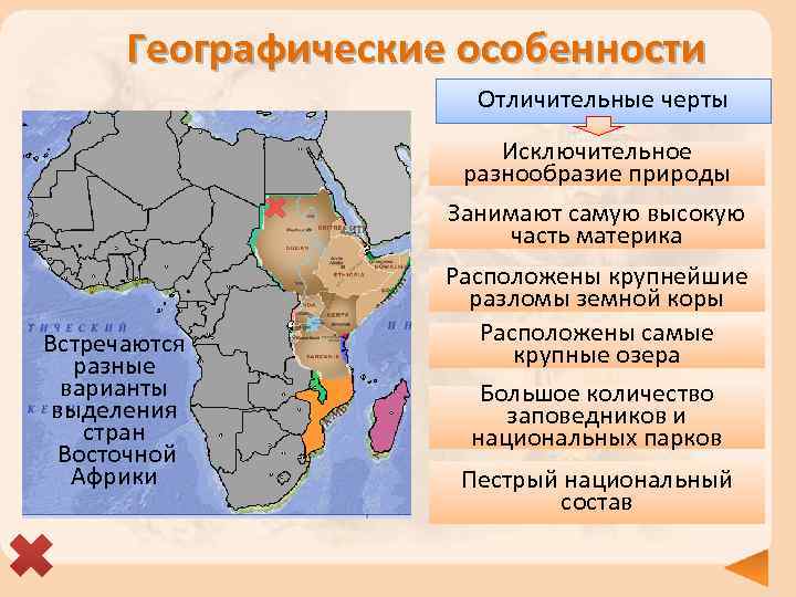 Geographical features Distinctive features Exceptional diversity of nature Occupies the highest part of the mainland There are different options for identifying the countries of East Africa The largest faults in the earth's crust are located large lakes A large number of reserves and national parks Motley national composition
 Geographical position? Ethiopia? Kenya 0° Area - 1.1 million km² Common border. Common neighbors - Sudan, Somalia. Capitals are large cities. Similarities Area - 582.6 thousand km² Kenya, unlike Ethiopia: - has access to the Indian Ocean; - crosses the equator; - smaller area. Differences
 Relief Ras Dashen 4 620 m Ethiopia Kenya Kenya 5 199 m Most of it is occupied by the Ethiopian Highlands. The highest point is Mount Ras. Dashen 4550 m, the fourth highest in Africa. The relief is extremely diverse - from coastal plains to mountain peaks and volcanoes.
 The relief of East Africa is the most seismic part of the continent. Mount Kilimanjaro and Kenya - highest peaks mainland are located along the fault line.
 Minerals The most important minerals In Kenya, the mineral resources of Ethiopia - the country's base - are poorly studied. natural gas, gold, soda mining, platinum, fluorite, common salt, polymetallic and rare gold and rubies, and other ore elements, potash and rock salt, etc. Gold washer in Ethiopia.
 The relief of Ethiopia The average height is 20003000 m. The highlands are sometimes called the "Roof of Africa". The eastern and southern edges of the highlands are steep ledges leading to a deep valley. The western ones are stepped, indented by the canyons of the Blue Nile and its tributaries. Seismicity is high.


 Climatic conditions The climate of the countries is subequatorial. The average temperature in both winter and summer varies within +14+28 C depending on the area. Despite the location of countries in low latitudes, at night
 Climatic conditions Ethiopia. Mostly Kenya. subequatorial. In the northeast - The tropical desert and subequatorial semi-desert type prevails. Climate depression. The western Afar is one of the hottest areas on earth. In most of the highlands around 23° C and average monthly rainfall. temperatures - from +15° C to +26° C on the coast. It rains around summer temperatures. Average annual 26° C, precipitation - in summer. rainfall - from 200 - 500 mm in the plains to 1000 - 1500 mm in the north of the country in the mountains is always hot and dry. central and southwestern regions. Droughts are frequent on the plains.


 Lake Rudolf, called by the locals "Basso-Noroc" (dark water), occupies a narrow tectonic depression up to 50 km wide and about 260 km long. Its area is 6.4 thousand square meters. km.
 Tana river largest river- Tana (length - about 750 km) begins in the mountains of Aberdare and, crossing the eastern edge of their foothills, forms a series of waterfalls. Large hydropower plants have been built at the Sven Falls and downstream.
 Lake Tana Source of the Blue Nile from Lake Tana The largest lake in the country was formed in a tectonic basin as a result of damming of lava flows.
 Abbay River 1 The largest of the rivers of Ethiopia - Abbay, in the lower reaches called the Blue Nile, originates in the form of a small river Small Abbay, which flows into the lake. Tana, and leaving it, gradually turns into a full-flowing river.


 The peoples of Ethiopia 1 2 4 3 95 languages are spoken in Ethiopia! Ethiopian skin color is light brown to dark chocolate, often with a reddish tint. The face is usually narrow, the nose is straight. Characterized by elongated body proportions.
 The people of Kenya 1 3 2 4 Kenya is a multicultural country with more than 40 various peoples. On the territory of the country, the borders of the main areas of settlement of the peoples of the 3 largest linguistic groups converge: Bantu, Nilotic and Cushites. About 65% of the African population of Kenya speaks Bantu languages.
 Ethiopia The capital of Ethiopia is Addis Ababa. The main industry is agriculture. Grain crops predominate in crop production. The main export crop is coffee. Pasture animal husbandry is developed. Industry is underdeveloped. These are mainly enterprises of the textile and food industries. Ethiopia is one of the poorest countries in the world in terms of economic development.


 Kenya The capital of Kenya is Nairobi. The main industry is agriculture. They grow coffee, tea, agave, corn. The main supplier to the world market is sisal. Meat and dairy cattle breeding is developed, in arid regions - herds of camels, sheep, goats graze. Industry is underdeveloped. In terms of tourism development, Kenya is one of the leading countries in Africa.

 Agave plantations Feverfew, or Dalmatian chamomile Sisal - agave fiber Collecting coffee


 Questions What forms of relief prevail in the countries Highlands, plateaus, faults in the earth's crust. East Africa? What are the highest points of the continent here are Kilimanjaro (5,895 m), Kenya (5,199 m). are? What ethnic groups are predominant here? equatorial race. Which country in East Africa is the birthplace of Ethiopia. coffee? What natural zone prevails in this part of the Savannah. Africa? Which state has the same name with Somalia. peninsula of Africa?
 Test 1. What natural areas prevail in East Africa? A. Tropical deserts B. Variable rainforests C. Savannahs and woodlands D. Equatorial forests 2. Which East African country has no access to the sea? A. Kenya B. Somalia C. Tanzania D. Ethiopia 3. In which country is Rudolph Lake located? A. Kenya B. Somalia C. Tanzania D. Ethiopia 4. Which country is dominated by the Amhara people? A. Kenya B. Somalia C. Tanzania D. Ethiopia natural phenomena how…? A. Catastrophic floods B. Earthquakes C. Frequent droughts D. Strong winds responses
 Test 1. What natural areas prevail in East Africa? A. Tropical deserts B. Variable rainforests C. Savannahs and woodlands D. Equatorial forests 2. Which East African country has no access to the sea? A. Kenya B. Somalia C. Tanzania D. Ethiopia 3. In which country is Rudolph Lake located? A. Kenya B. Somalia C. Tanzania D. Ethiopia 4. Which country is dominated by the Amhara people? A. Kenya B. Somalia C. Tanzania D. Ethiopia 5. Agriculture in East African countries is more often affected by such natural phenomena as…? A. Catastrophic floods B. Earthquakes C. Frequent droughts D. Strong winds
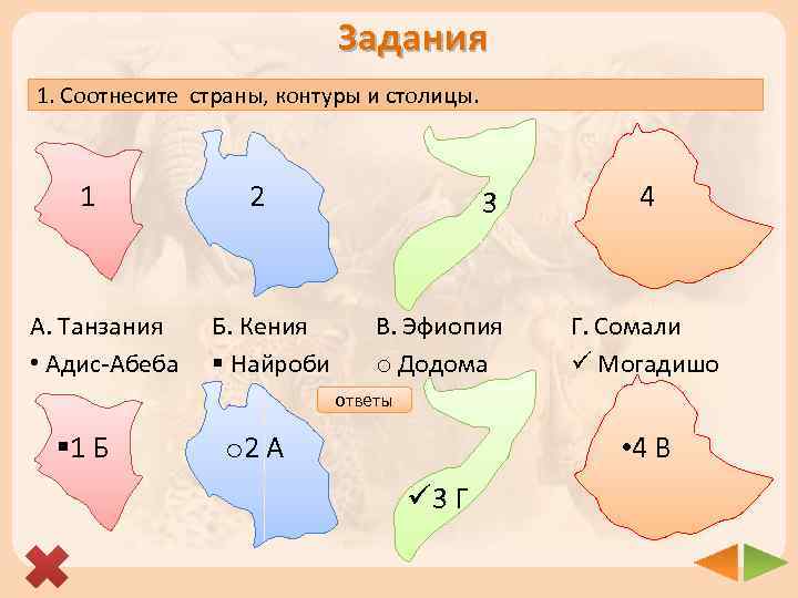 Tasks 1. Match the countries, contours and capitals. 1 2 3 4 A. Tanzania Addis Ababa B. Kenya § Nairobi C. Ethiopia o Dodoma D. Somalia ü Mogadishu Answers § 1 B o 2 A 4 C ü 3 D
 Tasks 1. Match the countries and geographic features. 1. Tanzania 2. Kenya A. Cape Ras Hafun 3. Ethiopia 4. Somalia C. Lake Tanganyika D. Port of Mombasa B. Mount Ras Dashen. A. B. C 1. 2. . D 3. answers 4.
 Resources http: //ya-ru. ru/wp-content/uploads/maps_africa. jpg - map of Africa http: //www 2. luventicus. org/mapas/africaoriental. gif - map of the country of East Africa http: //www. addictedtotravel. com/Resources/Images/2008/1/b 4 fb 22 b 050944327 a 621 cdeceee 91 a 0 c. jpg - map of East Africa http: //www. africa. org. ua/images/ethiopia_map. gif - map of Ethiopia http: //www. gotoafrica. ru/maps/small_kenia. jpg - map of Kenya Maps "Physical map" , "Climate map" , "Political map" , "Natural zones" , "Population" from the electronic supplement to the textbook "Geography. Land and people". Publishing house "Enlightenment", 2009 http: //sl. photo-traveller. net/Photo/Ethiopia-Djibouti 2009/221. jpg - Ethiopian Highlands http://where-to-go. org/media/1/20071202-zonarazlomov. jpg - view of the Rift Zone http: //img. travel. en/images 2/2008/09/object 161747/290908-28. jpg - Blue Nile canyons http: //img. travel. en/images 2/2008/09/object 161747/290908-30. jpg - Ethiopian Grand Canyon http://img. travel. en/images 2/2008/09/object 161747/290908-30. jpg - view of the Nile valley http: //romantic-places. ru/pics/pic 897-0. jpg - Ethiopian highlands http: //trendymen. ru/places/voyages/images_3/7_Erta-Ale-Volcano-Ethiopia. jpg - volcano "Gates of Hell" http: //interest-planet. ru/uploads/images/c/1/8/c/11/a 3 f 9 c 63 b 60. jpg - Dalol volcano http: //s 41. radikal. ru/i 093/1010/6 e/0 fe 674 b 5 de 64. jpg - Guyot volcano http: //s 002. radikal. ru/i 200/1010/15/28 d 014 d 48772. jpg - Lake Paradise http: //i 074. radikal. ru/1010/da/226 aa 4 fabc 6 c. jpg - crater fields http: //farm 4. static. flickr. com/3292/2717175246_618 e 3 d 10 s 8. jpg? v=0 – plains of Kenya http: //www. permex. en/userfiles/Image/kenya. JPG - Kenya http: //www. ecosystema. en/08 nature/world/37ken/01. jpg - northern part of the Serengeti plain http: //www. worldatlas. com/webimage/countrys/africa/afoutl. gif- contour map http: //byaki. net/uploads 1/1143151905_198964. jpg - Afar depression http: //www. mystic spot. ru/wp-content/uploads/envait 3. jpg - Lake Rudolph http: //dive. ru/_data/travel/0005790/image 005. jpg - Lake Rudolf http: //www. krugozormagazine. com/main/content/7-2010_Taina-1. jpg - Lake Rudolf
 Resources http: //www. vseneprostotak. en/wp-content/uploads/2010/06/052010 pv. jpg - p. Tana http: //www. rv prestige. en/upload/iblock/359/-ssvd. jpg - p. Tana http: //www. risk. en/i/post/29/29141_full. jpg - Lake Tana http: //tourism-world. ru/uploads/news/77/ozero_tana. jpg - Lake Tana http: //lah. ru/expedition/ephiop/tana/tl 05. jpg - source of the Blue Nile http: //www. liceoberchet. it/ricerche/geo 5 d_08/gruppo_c/testi/Lake_tana. jpg - Lake Tana http: //sl. photo-traveller. net/Photo/Ethiopia-Djibouti 2009/146. jpg - acacia forests http: //www. routes. ru/Photo. Files/b/7/6/f/b 76 f 4 d 6 bb 266491 b 84 a 5872 bf 04 c 5570/large/226. jpg - Danakil Desert http: //i 302. photobucket. com/albums/nn 95/sveta_by/LJ/2-2. jpg - savannas of Kenya http: //files. begonia. lv/system/user_files/region_images/nac. park%20 gori%20 Kenija_2. jpg - snowfields of Kenya http: //www. vostok-tour. com/africa 2. jpg - amhara http: //www. etnolog. ru/images/people/full/tigrai. jpg - tigers http: //upload. wikimedia. org/wikipedia/commons/thumb/e/e 3/Bedscha. jpg/200px-Bedscha. jpg - badge http: //photobucket. com/albums/ww 31/Nikolya-super/Ethiopia%20 exhibition/IMG_0787. jpg - galla (oromo) http: //bms. 24 open. ru/images/1 e 94732 ad 9 c 2 e 904 bf 7 bb 4 d 3 c 530 bd 84 - Bantu http: //img-fotki. yandex. ru/get/4110/bsw 2100. 9/0_2 ed 7 b_49 d 27 f 5 f_XL - Nilots http: //upload. wikimedia. org/wikipedia/commons/thumb/3/35/%D 0%9 F%D 1%80%D 0%BE%D 0%B 4%D 0%B 0%D 0%B 2%D 0% B 5%D 1%86_%D 0%B 8%D 1%80%D 0%BA%D 1%83. jpg/200 px%D 0%9 F%D 1%80%D 0%BE%D 0%B 4%D 0%B 0%D 0%B 2%D 0%B 5%D 1%86_% D 0%B 8%D 1%80%D 0%BA%D 1%83. j pg - Kushites http: //www. svali. ru/pictures/141/r_p_25025 ae 501 d 1 cd 60144 cfc 30 f 7 e 2 f 699. jpg - Maasai http: //www. selamta. net/Addis_Abeba. jpg - Addis Ababa http: //www. poedem. en/images/catalogs/southafrica/Pic/Cities/johannesburg/Hillbrow. With. The 269 m. JGStrijdom. Tower_Johannesburg_South. africa. JPG- Addis Ababa http: //img 1. worldpoi. info/upload/pics/thumb/fs 400 x 300 px-4600424954 c 1 ccb 8 c 7 b 8 c 2921291147. jpg - waterfall on the river. Abbay
 Resources http: //img. tape. ru/news/2008/04/21/ethiopia/picturesmall. jpg - Prime Minister of Ethiopia http://ostranah. en/ethiopia_flag. gif - flag of Ethiopia http: //ostranah. en/ethiopia_emblem. jpg - coat of arms of Ethiopia http: //photo. kuda. ua/wpcontent/images/s/ethiopia/D 4 EEF 2 EEE 3 F 0 E 0 F 4 E 8 FF 20 DDF 4 E 8 EEEFE 8 E 82 E 20 CAEEF 4 E 5 E 9 EDFBE 520 EFEBE 0 EDF 2 E 0 F 6 E 8 E 820 E 2 FBF 1 EEEAEEE 3 EEF 0 FCE 520 DDF 4 E 8 EEEFE 8 E 8. jpg - coffee plantations http: //www. gerka. ru/wordpress/wp-content/uploads/2009/09/kofe-zeremonia-2708 -1 -150 x 150. jpg - coffee ceremony http://farm 5. static. flickr. com/4083/5095688835_fcd 0 b 846 e 1. jpg - Ethiopian livestock http: //www. secator. en/ethiopia-avs/small/CRW_5626_JFR. JPG - beekeeping http: //hainan 2007. users. photofile. ru/photo/hainan 2007/96054520/xlarge/107232673. jpg - weaving http://images 3. webpark. en/uploads 53/081204/another_01. jpg - poverty http: //www. the-village. en/1273798411/assets/article_image-image/79/58/865253/article_image-article. jpg - Ethiopian dwellings http: //www. photobank. ru/img/R 006-2768. jpg? size=l - poverty http: //limpopo-tour. ru/foto/Ethiopia/ethiopia. jpg - poverty http: //www. vokrugsveta. en/img/cmn/2007/01/15/020. jpg - Ethiopian agriculture http: //www. indpg. ru/images/nik/2008/06/Pic/Zarub 1-1. gif - map of Ethiopia http: //wyg. su/i/llustration/7/b/7 bcb 2 feb-21 cd-36 de-b 3 bc-4 f 2 b 24374628. jpg - oil production http: //www. shirkunov. org/maps/kenya_mineral. jpg - mineral map of Ethiopia http: //www. vokrugsveta. en/img/cmn/2007/04/08/019. jpg - gold washer http: //kenyanview. com/IMG_0865_Nairobi_skyline. jpg - Nairobi http://www. happytellus. com/img/nairobi-view-1_231. jpg - Nairobi http://www. travel professional. en/images/flags/big/KE. jpg - flag of Kenya http: //cultinfo. en/fulltext/1/009/001/232602174. jpg - coat of arms of Kenya http: //www. islamicpopulation. com/africa/Kenya "s%20 Muslim%20 Leaders%20 Throw%20 Support%20 to%20 Op position_files/image 002. jpg - President of Kenya
 Resources http: //i 1. trekearth. com/photos/43511/slide-532 web. jpg - agave plantations http: //sanabis. ru/mat/kopna. jpg - sisal http: //medgrasses. en/img/piretrum. jpg - pyrethrum http: //coffemanika. ru/wp-content/uploads/2010/02/Kenya_Coffee. picking. jpg - coffee picking in Kenya http: //www. ifad. org/photo/images/10158_c 31 s. jpg - animal husbandry in Kenya http: //www. corbisimages. com/images/67/7 E 2 B 57 F 9 -4 DD 1 -4 A 47 -B 86 D-3 B 2 C 9 C 87651 A/NW 002579. jpg - Kenya livestock http: //www. library. en/3/focus/photos/camel_01. jpg - camel breeding in Kenya http: //img. travel. ru/images 2/2007/03/object 107514/j 7. jpg - Kenyan fishermen http://samysafari. com/wp-content/img/28. jpg - safari http: //www. well. ru/upload/iblock/ac 9 a 0 aa 6 e 49561 d 35 dc 96 dc 109 c 8 c 1 e 3. jpg - national map parks http: //www. tourism ru/country_gallery/92/154. jpeg - tourism http: //www. tourism ru/country_gallery/92/48. jpeg - tourism http: //www. ukrmap. kiev. ua/index. php? id=388&lang=ru – climate map http: //upload. wikimedia. org/wikipedia/commons/thumb/3/37/Dejen_misura_da_cima_W. jpg/300px. Dejen_misura_da_cima_W. jpg - Rasa-Dashen city http: //limpopo-tour. ru/foto/Zair-Kongo/kongo. jpg - Tanganyika